142 m away
Lower Sauma Ridge Trail
Interpretive trail through lush rainforest to a coastal panorama, with the option to scramble down the rocks and swim in deep tide pools.
Moderate Hiking
- Distance
- 591 m
- Ascent
- 71 m
- Descent
- 71 m
One-of-a-kind adventure in the national park, scaling many ropes and ladders through thick jungle to reach the top of Mount Alava.
Hiking Severe

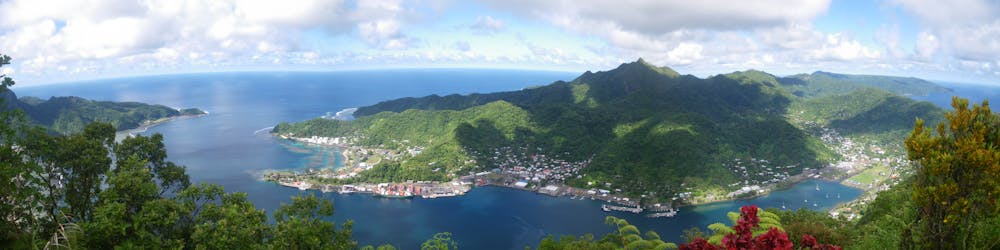
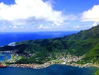
Mount Alava is the sweeping ridgeline over Pago Pago, near the center of Tutuila Island. The standard route to the top is the Mount Alava Trail west of town, but the trail described here is a much more adventurous alternative to reach the same summit. Beginning from the other side of the mountain, near Vatia Village, the Mount Alava Adventure Trail ascends Upper Sauma Ridge, using a series of ropes and ladders plus tight switchbacks. It’s an exhilarating and highly physical route that resembles a ropes course as much as it does a trail. This one should only be attempted by very fit hikers who aren’t afraid of heights.
The “ladders” are really more like steep stairs, but they're made of logs linked with cables, which can sway a bit underfoot. Hand lines of cable or rope are hung over them, allowing the use of the arms to pull up and to balance. These features are maintained but perhaps not regularly, so beware of loose and slippery steps. The national park states that the trail contains 56 ladders and 783 steps in total.
There are some flatter spots at which to rest and glimpse views through the trees, but for the most part, it’s a full-on sweaty slog all the way to the summit. Bring plenty of water and food to stay fueled for the duration. Muddy conditions will exacerbate the difficulty, so it’s best to save this adventure for a drier day.
To find the start, park at the trailhead for Lower Sauma Ridge. From there, walk a short distance west along the road, and look for the small hiking sign. The trail begins with a rope and ladder to climb into the forest right away.
The Park Service recommends making a loop instead of backtracking, in order to avoid two-way traffic on the ladders. After reaching Alava’s summit and taking in the views, you’ll reverse only the uppermost ladders, then turn onto another trail. This one descends in a more traditional manner (no ladders) to Vatia Village along a different ridgeline. Near the bottom, it connects with a residential lane that leads to the coastal road. From there, you must walk a mile on the highway or catch a ride to get back to your car.
Sources: https://www.nps.gov/npsa/planyourvisit/upload/Day-Hikes-SBNPSAhigh-res.pdf http://www.panamintcity.com/americansamoa/mtalavaadventuretrail.html
Severe
Hiking challenging trails where simple scrambling, with the occasional use of the hands, is a distinct possibility. The trails are often filled with all manner of obstacles both small and large, and the hills are very steep. Obstacles and challenges are often unexpected and can be unpredictable.

Some trail sections have exposed ledges or steep ascents/descents where falling could cause serious injury.
Little chance of being seen or helped in case of an accident.
142 m away
Interpretive trail through lush rainforest to a coastal panorama, with the option to scramble down the rocks and swim in deep tide pools.
Moderate Hiking
1.2 km away
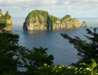
Short walk to the sea cliffs at the tip of Tutuila Island and a view of Pola Island.
Easy Hiking
1.3 km away
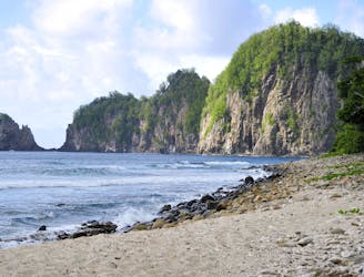
Scramble up and down through thick rainforest to find a truly isolated, cliff-lined beach.
Severe Hiking
6.7 km away
One of American Samoa’s must-do hikes, this wide trail through the jungle leads to panoramic views atop the island’s central mountain.
Moderate Hiking
7 routes · Hiking

63 routes · Alpine Climbing · Hiking