1.7 km away
Mount Solitary Walking Track
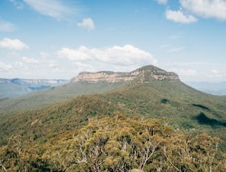
A challenging, multi-day hike boasting spectacular views, bush camping and a variety of native forests.
Extreme Hiking
- Distance
- 34 km
- Ascent
- 2.6 km
- Descent
- 2.6 km
Exposed, hard to follow, not for the faint-hearted, but for those who tackle Lindeman Pass, the adventure is worth it.
Hiking Severe

A trail steeped in history, the Lindeman track was the brainchild of Charles Lindeman - a local who, in 1898, wanted to find a trail that linked the Katoomba tracks with Wentworth Falls. It was far from easy, and some 30 years after its conception the trail was still not complete.
There are many who argue that this is still the case.
If you're heading out on the Lindeman Pass be warned: many have tried, and plenty have got lost along the way (so many that the Katoomba Police Station offer Personal satellite tracking devices for those heading out on the trail). While the Lindeman Trail follows a defined route, it is not always clearly marked as it winds its way through the forests. What's more, it's not easy. Exposed in places, slippery in others, the Lindeman Pass requires a good technical bushwalking skills and an ability to navigate tough terrain. Download maps before you go!
Still interested? If so, be prepared for an epic adventure that boasts sensational views and challenges aplenty. Starting out from Katoomba, follow the Federal Pass down to Linda Falls, then keep on going to Lindeman Pass. From that point, there is only one (official) track as you skirt the lifts. Stay alert and keep navigating as the trail can be hard to follow at times.
Before setting out on a trail like this be sure to check the NPNSW website. Bush fires and heavy rains have affected trail conditions throughout the Blue Mountains. If you are not confident on technical trails, do not do this hike.
Severe
Hiking challenging trails where simple scrambling, with the occasional use of the hands, is a distinct possibility. The trails are often filled with all manner of obstacles both small and large, and the hills are very steep. Obstacles and challenges are often unexpected and can be unpredictable.

Some trail sections have exposed ledges or steep ascents/descents where falling could cause serious injury.
Little chance of being seen or helped in case of an accident.
1.7 km away
A challenging, multi-day hike boasting spectacular views, bush camping and a variety of native forests.
Extreme Hiking
4 km away
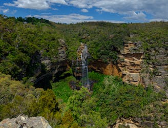
Moderately challenging, this 6.2km loop showcases the best of the Blue Mountains scenery, not to mention waterfalls... lots of waterfalls.
Moderate Hiking