395 m away
GR20
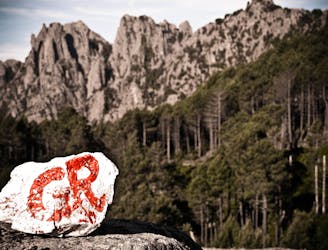
Considered to be one of the best and toughest long hikes in Europe, this 180 kilometre hike is a magnificent journey down the spine of Corsica.
Difficult Hiking
- Distance
- 23 km
- Ascent
- 700 m
- Descent
- 1.8 km
Trou de la bombe via le promontoire
Hiking Moderate

This is a popular hiking route which is generally considered to be moderate. It's not remote, it features medium exposure and is typically done between March and December. From a low point of 1.2 km to the maximum altitude of 1.4 km, the route covers 7.7 km, 340 vertical metres of ascent and 346 vertical metres of descent.
Trail to the Bomb's hole without following the usual signs
Moderate
Hiking along trails with some uneven terrain and small hills. Small rocks and roots may be present.

The trail contains some obstacles such as outcroppings and rock which could cause injury.

Close to help in case of emergency.
395 m away
Considered to be one of the best and toughest long hikes in Europe, this 180 kilometre hike is a magnificent journey down the spine of Corsica.
Difficult Hiking