3.9 km away
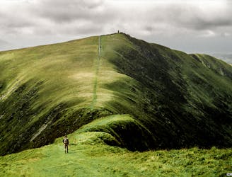
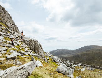
Snowdon Horseshoe including Crib Goch
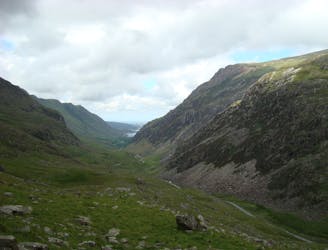
Perhaps it's only fitting that the highest mountain in Wales boasts the country's greatest all-day scrambly ridge traverse.
Extreme Hiking
- Distance
- 12 km
- Ascent
- 1 km
- Descent
- 1 km
A good challenge for any fit walker, which also is one of the best walks in Snowdownia.
Hiking Extreme

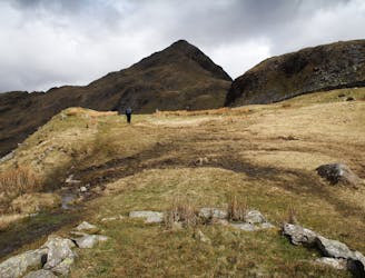
The route ascends all the peaks over 3000 feet starting with Snowdon (Yr Wydffa) and finishing with Foel Fras in the Carneddau.
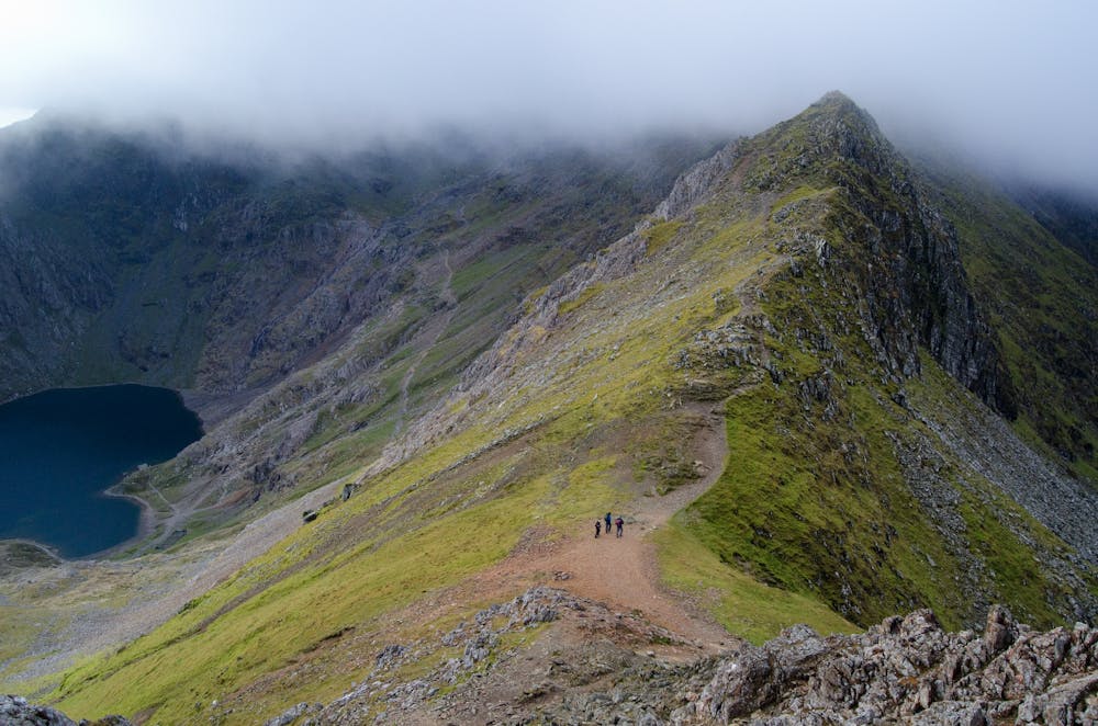
The traditional way of doing the Welsh 3000s is starting at Snowdon and finishing at Foel Fras. Some walkers may prefer to start with Crib Goch or do the route in reverse. There are many variations. The route described is one of the shortest and least boggy ways of doing all the peaks, but there are some steep bits! Start by making your way to the summit of Snowdon by either the Pyg Track or Miners Track. Snowdon is the first peak and where the challenge starts. To get an early start, you may choose to bivouac on the summit near the cafe but this can be a fairly dismal experience. Touch the trig point on the summit of Snowdon, make a note of the time and set off in a north-westerly direction. Follow the good track down beside the railway to the pointed stone obelisk where the Pyg track meets the ridge. Follow the broad path that ascends to the north-east until the trig point at the summit of Garnedd Ugain is reached.
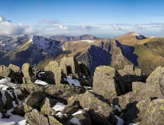
From the trig point, descend steeply and scramble along the ridge in an easterly direction. The first major obstacles to be reached are known as the Crib Goch Pinnacles. Climb straight over the first pinnacle and descend the other side with care along a narrow rock shelf to the safety of a gully. This section is very exposed! Alternatively go around to the right of the pinnacle before climbing over it. Climb up the gully and ascend the second pinnacle up its left hand side. After another 200 metres you should reach a small pile of stones that mark the true summit of Crib Goch.
Continue north-eastward along the knife-edged ridge enjoying the views. The right-hand side of the ridge for this section is much less exposed than the other side; the bold may choose to walk along the very top of the ridge, but mere mortals will prefer to scramble just below the ridge using its top as a hand rail. Eventually you should reach Crib Goch's north summit where an obvious continuation descends towards the Pen y Pass, however you need to follow the ridge as it curves around to the north. As the ridge comes to an end, descend the pinkish screes in a north-westerly direction via an indistinct path. Set your compass to 312 degrees and follow this bearing to a steep descent down a little gully. Follow the faint path, at first to the west and then to the north west, to another short descent. Continue descending in a northerly direction to cross a stream. Follow a path besides the stream going downwards (north-easterly) to a good track over a bridge at Blaen-y-nant. Finding the best way down from the north ridge of Crib Goch is not easy and this is one section that you may wish to recce first (but in reverse) from Blaen-y-nant. If doing the route over three days, you could end the first day here or at Nant Peris.
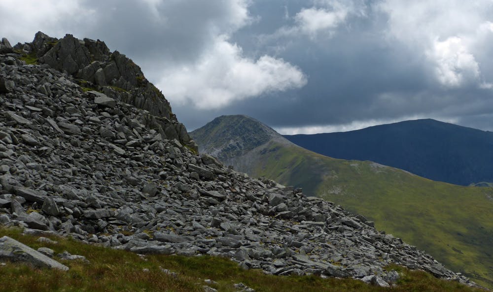
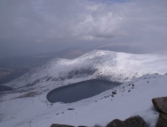
From Blaen-y-nant follow the road for 2.2 km to Nant Peris passing the Vaynol pub. Turn right along a walled lane by a chapel towards the Ty Isaf campsite, past the campsite entrance and follow the public footpath (sign) along the lane. Go over a ladder style and continue along the lane. The route now passes through a metal gate on the right and heads up the hillside in a northerly direction to reach a footbridge. Cross the bridge and follow the track upwards through often boggy ground. Continue upwards heading for the summit of Elidir Fawr, which is to the north and marked by a cairn and a stone shelter. The views from the summit are tremendous and Anglesey can clearly be seen unless it is misty.
From the summit of Elidir Fawr, head north-eastwards along a good path. The path eventually curves round to the south and heads towards Y Garn. Continue southwards rather than following the path up to left which goes up Foel Goch. The summit of Y Garn has a wind shelter and has one of the finest views in Wales.
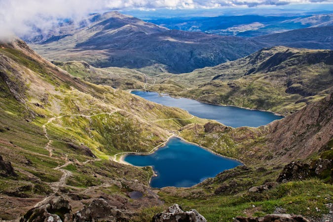
From Y Garn continue in a south-easterly direction to a lake (Lyn y Cwn) where you can refill your water bottle. Go round to the left of the lake and start your ascent up the steep screes towards Glyder Fawr. At the top of the scree you will reach a barren plateau that contains lots of rock features. Glyder Fawr is the highest of these rock features and lies slightly to the left of the main path.
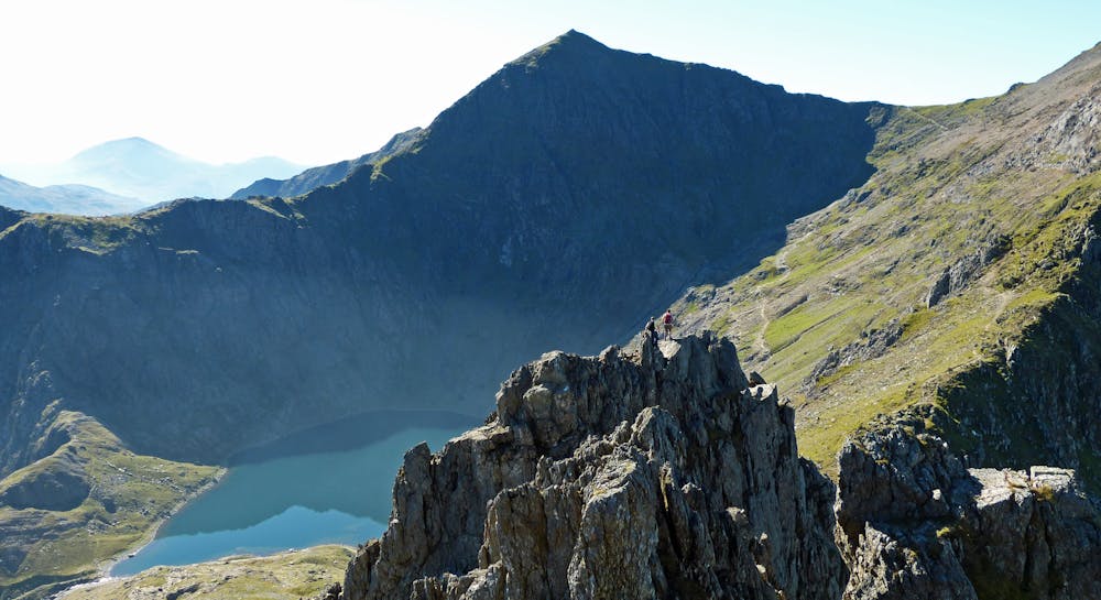
From Glyder Fawr, follow the path eastwards heading directly for the spiky and intimidating rocks of Castell y Gwynt (Castle of the Winds). These can be avoided by going around to the right of them, but it is much better to scramble over them and this is much easier than it looks (grade 1). After reaching the other side of these rocks, the pile of huge boulders that mark the summit of Glyder Fach can be clearly seen ahead. Follow a rocky path heading straight for them. The ascent of these boulders can be problematic; perhaps the easiest way is to go around to the right of them and then scramble upwards to finish up a small slab.
After slithering back down from the summit of Glyder Fach follow the path past the famous Cantilever rock (a balanced slab of rock that looks very precarious and is the scene of many photographs). From here head north-eastwards towards an obvious descent (don't take the right hand path that leads eastwards). The descent beside Bristly Ridge is steep and loose and requires care. At the bottom of the scree slope cross a ladder style and head towards Bwlch Tryfan - this is the col below Tryfan. The summit ahead is the South peak and this can be avoided by going around to its left (the true summit of Tryfan cannot be seen from here). Scramble upwards trying to find the easiest way up (grade 1) until the col behind the south peak is reached and the summit blocks of the true summit can be seen. Head straight for these blocks (known as Adam and Eve). The daring may choose to jump between the summit blocks but this may prove to be a foolish way to end your walk.
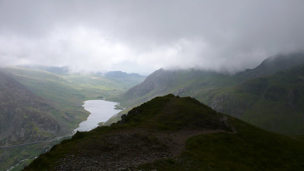
From the summit go northwards to reach a col below Tryfan's north peak and take a path that leads steeply downwards to the left (westwards). After scrambling down a gully, a set of stone steps can be seen going heading off to the north-west. Follow these to their end and continue along a path that leads down to the A5 at a point about halfway along Llyn Ogwen, travel along the A5 westwards to Ogwen Cottage. There are toilets here and a small shop where you can get food and water. If doing the route over three days, you could end the second day here.
From Ogwen Cottage continue along the A5 (westwards) and just after the bridge go through a gap stile in the wall on the righthand side. Go slightly left and then upwards to meet a series of stone steps. which are followed until their end. Continue up the hillside over some scree and blocks until the summit plateau is reached. Head rightwards (north-east) to reach the actual summit of Pen yr Ole Wen where there is a stone shelter.
From Pen yr Ole Wen the path descends north-westwards to meet the ridge that leads to Carnedd Dafydd.
From Carnedd Dafydd continue along a path that follows the ridge keeping just to the right of the steep drop above the Black Ladders cliff. Where the path reaches the slopes of Carnedd Llewelyn and starts to ascend its southern flank, take a faint path to the left which contours round to the north-west. This path is very vague in parts but if you maintain the same height, you should reach a good path on a ridge that joins Yr Elen with Carnedd Llewellyn. Follow the path north-westwards to the small pile of stones that mark the summit of Yr Elen.
From Yr Elen retrace your steps along the ridge and then continue along the path upwards towards Carnedd Llewelyn. After reaching the summit plateau head towards a large stone shelter and a pile of stones that marks the summit.
From Carnedd Llewelyn follow a cairned path heading northwards at first, and then north-eastwards to the loose pile of rocks that mark Foel Grach.
From Foel Grach descend steeply (north-eastwards) past a small refuge shelter and follow a path heading northwards and then turning slightly to the north-west where the rocks of Garnedd Uchaf can be seen straight ahead. The main path goes to the right of these rocks, but continue heading straight towards them and clamber over them to locate the highest point.
From Garnedd Uchaf head north-eastwards to reach a good path that goes to the left of a wall. Follow the path until the trig point that marks the summit of Foel Fras summit can be seen. Leave the path and head over to the trig point and spend a while admiring the views over towards the Great Orme near Llandudno. This is the final peak of the Welsh 3000s and you will have walked 21.4 miles from Snowdon to get here. However before you can relax, there are several more miles of walking to do.
From Foel Fras, walk north-westwards along a broad ridge gradually descending to a col. Take a very faint path to the left that leads downwards to a clearly visible reservoir (Llyn Anafon). The path is hard to follow and descends through some fairly boggy ground. If you lose the path, head towards the righthand side of the reservoir. When you reach the reservoir head towards a very good track. Follow the track for another 3 miles. A third of a mile after the track swings to the north a path leads down to the left to reach a gate at the end of a road and a small carpark. Hoepfully, you will have arranged for someone with transport to meet you here. If not, it is another 1.8 miles to Abergwyngregyn.
© GeoffRadcliff - UKHillwalking.com, Oct 2011
Extreme
Scrambling up mountains and along technical trails with moderate fall exposure. Handholds are necessary to navigate the trail in its entirety, although they are not necessary at all times. Some obstacles can be very large and difficult to navigate, and the grades can often be near-vertical. The challenge of the trail and the steepness of the grade results in very strenuous hiking. Hikes of this difficulty blur the lines between "hiking" and "climbing".
3.9 km away
Perhaps it's only fitting that the highest mountain in Wales boasts the country's greatest all-day scrambly ridge traverse.
Extreme Hiking
4.3 km away
Snowdon isn’t short of great walking routes to its crowded summit, but if you think they are all infested with other folk you can think again.
Difficult Hiking
4.3 km away
A grassy stride along elegant curved arêtes, the traverse of the main ridge linking all the summits in the range is a classic Welsh walk, with a rare sense of peace and spacious seaward views.
Severe Hiking
6.3 km away
This walk around Cnicht and it aqueous environs is one of the most enjoyable in Snowdonia offering some of the finest views in the national park, a smidgeon of optional scrambling and a tour of the most enchanting llynau imaginable.
Difficult Hiking
6.6 km away
This is a circular six mile walk, starting and ending at the little footbridge at Beddgelert.
Easy Hiking
7.2 km away
One of Snowdonia's most classic hikes along one of its most scenic ridges
Difficult Hiking
8 km away
Snowdon's horseshoe may have the majesty, but Ogwen's own circular classic boasts more and better scrambling.
Extreme Hiking
8.5 km away
If it’s a superb walk in relative solitude you’re after then folk in the know will point you at those big old lumps where scenes of genuine grandeur can also be won, but unlike the cheap thrills of their Ogwen brethren, the secrets of the Carneddau must be earned.
Difficult Hiking
8.8 km away
Hideously scarred and cruelly exploited it may well be, but Elidir Fawr is often the choice of the connoisseur when a quick 3000er is the order of the day.
Difficult Hiking

18 routes · Alpine Climbing · Hiking
10 routes · Hiking