7.6 km away
Whitesands to Abercastle
Pembrokeshire Coast Path
Difficult Hiking
- Distance
- 23 km
- Ascent
- 722 m
- Descent
- 723 m
Pembrokeshire Coast Path
Hiking Difficult

This is a popular hiking route which is generally considered to be difficult. It's remote, it features high exposure and is typically done between March and October. From a low point of 4 m to the maximum altitude of 57 m, the route covers 20 km, 425 vertical metres of ascent and 431 vertical metres of descent.
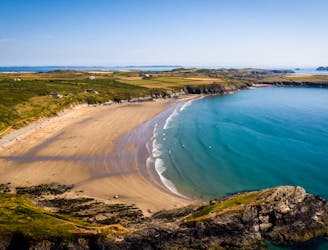
Wonderful views out to Ramsey Island and great beaches along the way.
Difficult
Hiking trails where obstacles such as rocks or roots are prevalent. Some obstacles can require care to step over or around. At times, the trail can be worn and eroded. The grade of the trail is generally quite steep, and can often lead to strenuous hiking.

Some trail sections have exposed ledges or steep ascents/descents where falling could cause serious injury.

Away from help but easily accessed.
7.6 km away
Pembrokeshire Coast Path
Difficult Hiking