315 m away
Oops and Poops

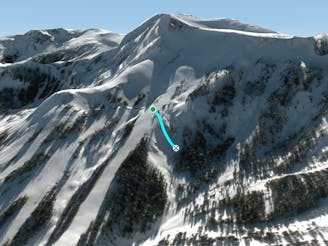
Hidden gem of a run that has steeps, cliffs, glades and great north facing snow
Difficult Freeride Skiing
- Distance
- 438 m
- Ascent
- 0 m
- Descent
- 209 m
A good series of narrow, tree line chutes at the bottom of Chamoix. There are many ways to enter. If you find a small chute at the top of the "Gully" part of Olympic, enter from there (were the dead tree is.)
Freeride Skiing Difficult

This is a popular freeride skiing route which is generally considered to be difficult. It's not remote, it features low exposure (e1) and is typically done between January and March. From a low point of 2.5 km to the maximum altitude of 2.6 km, the route covers 338 m, 13 vertical metres of ascent and 85 vertical metres of descent. It's graded 4.2 and Labande grade 4.
On a powder day, this run can be awesome. There are some small to medium cliff that should be jumped on a powder day. This line holds very nice snow.
Difficult
Serious gradient of 30-38 degrees where a real risk of slipping exists.

Exposure is limited to that of the slope itself. Getting hurt is still likely if the slope is steep and/or the snow is hard.
Close to help in case of emergency.
315 m away
Hidden gem of a run that has steeps, cliffs, glades and great north facing snow
Difficult Freeride Skiing
341 m away

Short and extremely steep and rarely skied line above Chamoix
Extreme Freeride Skiing
348 m away

An extremely steep chute that generally has a cornice with a runout into Chamoix
Severe Freeride Skiing
378 m away

Classic early season overhanging chute that funnels into Jim's Run
Difficult Freeride Skiing
556 m away

Series of chutes located in Wagon Wheel Bowl off of Chair 6
Difficult Freeride Skiing
705 m away

Great powder hike-to run above Rabbit Runs with a few rock features
Difficult Freeride Skiing
1.1 km away

The most conservative line in the zone that avoids rocks and cliffs
Difficult Freeride Skiing
1.1 km away

Steep sunny zone with some fun obstacles
Difficult Freeride Skiing
1.2 km away

Steep exposed ridge with rocky features
Difficult Freeride Skiing
1.2 km away
A narrow chute that usually is a straightline
Difficult Freeride Skiing

7 routes · Freeride Skiing