4.9 km away
Mount Diablo Grand Loop
A scenic circuit around the higher elevations of the Bay Area's most prominent mountain.
Moderate Hiking
- Distance
- 9.9 km
- Ascent
- 563 m
- Descent
- 563 m
The worthy way to summit Mount Diablo: hiking it bottom to top on remote and super-scenic trails.
Hiking Difficult

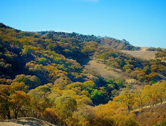
This is one of the most spectacular inland hikes in the Bay Area, and it climbs the region’s most prominent mountain—Mount Diablo. Airy ridgelines, colorful chapparal, and craggy sub-peaks lead the way to Diablo’s summit. The mountain does have a paved road to the top, but this hike takes a different and more scenic route. For most of the way you won’t see or hear traffic, but you’ll of course share the summit with motorists.
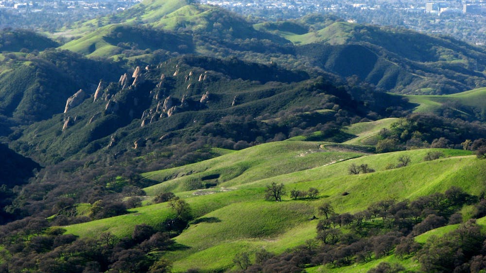
What makes this hike so spectacular are the views from the slopes and ridges on the ascent. Mount Diablo is covered primarily with meadows and brushy chaparral, which means few tall trees to obstruct line of sight. That also means very little shade. Therefore, this hike is best on a clear but cool day. In the absence of fog or haze, you can see across the Bay in one direction and all the way to the Sierra Nevada in the other.
The hike is mapped here as a loop from Mitchell Canyon Trailhead, within Mount Diablo State Park. The ascent is mostly on hiker-only trails, with some sections that are rugged or overgrown. The descent is mostly on dirt roads which are also open to mountain bikes. Trail junctions are well signed, for the the most part. This route has a lot of turns that must be made, so consult the map to stay on track.
Begin on Mitchell Canyon Road, then turn on Eagle Peak Trail to begin the long ascent, which gets very steep in a few spots. Initially you’ll climb forested north-facing slopes, but soon break into the open at an outcrop called Mitchell Rock, with a nice view over Mitchell Canyon. The scenery only gets better from there. You’ll contour along brushy slopes to gain the first named summit, Twin Peaks. That’s where the trail gets really awesome, as it traverses the spine of a grassy ridgeline with sweeping views on either side. It crosses another craggy summit named Eagle Peak, then descends to a saddle and crosses Meridian Ridge Fire Road.
If the sometimes-crowded summit of Mount Diablo doesn’t interest you, or if you don’t have time for the full hike, you can cut the loop short by taking Meridian Ridge Road down to Mitchell Canyon. To keep going up, continue along the panoramic ridgeline to the next major junction at Prospector’s Gap. From there, North Peak Trail leads toward the summit. You’ll have to cross the paved road once, but a hiking trail runs separate from the road to reach the visitor’s center perched on the summit. You can rest inside and refill your water before heading back down.
To complete the loop, walk along the road briefly to get to Juniper Trail. From there it’s a pleasant stroll down a forested ridgeline, and through a campground, to meet the fire roads that lead the rest of the way down Mitchell Canyon. The road starts out very steep but becomes more mellow farther down.
The canyon is pretty, with chaparral and conifer-covered slopes and a seasonal stream, but it’s somewhat monotonous compared to trails on the ascent. If you’re the type of hiker who prefers your best views on the downhill, simply hike this loop in the opposite direction, or retrace your steps to make it an out and back.
Sources: https://socalhiker.net/hiking-mitchell-canyon-to-mount-diablo/ https://bahiker.com/eastbayhikes/mdsp/mcep.html https://www.parks.ca.gov/pages/517/files/mtdiablobrochure.pdf
Difficult
Hiking trails where obstacles such as rocks or roots are prevalent. Some obstacles can require care to step over or around. At times, the trail can be worn and eroded. The grade of the trail is generally quite steep, and can often lead to strenuous hiking.

The trail contains some obstacles such as outcroppings and rock which could cause injury.
Away from help but easily accessed.
4.9 km away
A scenic circuit around the higher elevations of the Bay Area's most prominent mountain.
Moderate Hiking

12 routes · Hiking
7 routes · Hiking