
72 routes · Hiking
Miles 266.1-329 of the northbound PCT: Descending from the mountains through a gorge flowing with water, into a desert basin with a picturesque reservoir.
Hiking Moderate

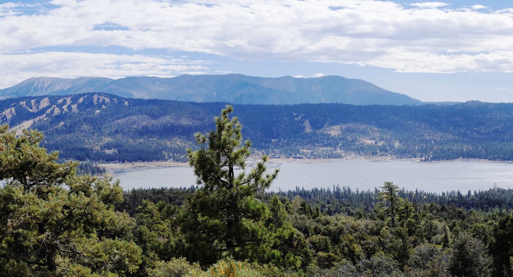
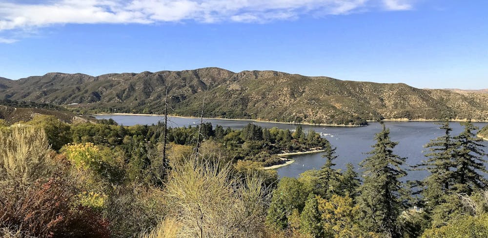
This is the continuation of California Section C northbound from Highway 18 near Big Bear Lake. It begins among often-busy hiking trails and OHV roads near this lively mountain town, but finds more seclusion as the PCT moves down in elevation, along babbling creeks and bouldery hillsides. It eventually dives into the gorge of Deep Creek, where crowds may appear at swimming holes and the hot springs, but the trail soon leaves them behind, marching deeper into the meandering canyon. Eventually, the PCT emerges on the fringe of the Mojave Desert, and a large body of water soon appears among the chaparral hills. This is Silverwood Lake, and a sign that California Section C is nearing its end.
Big Bear is a common stopover and resupply for PCTers, though the town is some distance off trail. Highway 18 provides an option to hitch to/from, but other roads and trails connect as well. It’s not a zone for finding solitude on the trail, but the bustle of this mountain town may feel welcome to northbound hikers coming out of the San Gorgonio Wilderness.
(Doble Camp)https://www.fs.usda.gov/recarea/sbnf/recarea/?recid=74180 (NB mile 268.6) is a popular PCT trail camp with water, just 2.5 miles northbound from the highway. From there, the PCT climbs higher in elevation and reaches Bertha Ridge (NB mile 277.5), where the popular Cougar Crest Trail comes up from Big Bear Lake. This is where you’ll get views over the lake and the city. Also on the horizon is Mount San Gorgonio, likely capped with snow. Other panoramas on the ridge feature the San Gabriel Mountains, where the northbound PCT is eventually headed.
Moving along Bertha Ridge and down to Holcomb Creek, the trail rolls easily through expansive pine forest on gentle slopes. Holcomb Creek (first crossing at NB mile 286) has flowing water in the spring but can go dry by fall. Check the (PCT Water Report)https://pctwater.com/ for updates. Dispersed camp spots are plentiful in this stretch along the creek, but keep in mind that you are never far from potentially noisy jeep roads here.
The trail loosely follows the creek and side drainages for the next several miles, moving generally downhill and through varied forest. North-facing slopes are forested and cool, while south aspects are desert-like. After climbing away from Holcomb Creek and crossing a few miles of drier uplands, the trail drops to Deep Creek and crosses it on a wooden bridge (NB mile 298.5). This is also the junction for Splinters Cabin, normally an overcrowded trailhead for the short hike to Aztec Falls. Access closed in 2020 to address overuse, however, and it may or may not reopen in 2021. Hiking through on the PCT is still allowed, but the falls are off limits as is the Splinters Cabin trailhead.
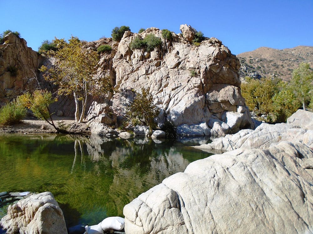
The PCT proceeds to follow the Deep Creek gorge for quite a long time, though almost always on steep slopes well above the cliff-lined creek. To get water, you may need to look carefully for safe places to scramble down. Seasonal sources may be found along the trail as well. One place the trail descends easily is at Deep Creek Hot Springs (NB mile 308), which is worth stopping for a soak if you don’t mind the clothing-optional atmosphere. Note that camping is not allowed within one mile of the hot spring.
Past the hot spring, the PCT continues to twist through the bouldery canyon, crossing the creek once on another bridge (NB mile 310) and taking to even sunnier, drier slopes on the other side. The trail then descends to the Mojave Forks Dam, in an area which can flood in a wet spring. You’ll have to step or wade across the creek here, so if there’s a lot of water or mud you might walk the road over the dam as a bypass.
After that, the trail crosses a paved road where there is a parking area (NB mile 314.3), making one option for starting or ending a section hike. The trail then meanders along brushy and rocky hillsides, overlooking a broad, grassy valley on the way to Silverwood Lake Recreation Area. You’ll have to briefly join some paved roads to get around the power plant and dam outlet, but then the trail returns to natural surface and climbs a hill to reveal the lake. A few more miles of trail traverse the hillsides above the shore, and short side trails lead down to beaches on the water. Potable water and other amenities are available at Cleghorn Picnic Area at the southwest end of the lake. There are campgrounds nearby, including hiker/biker tent sites available for a fee. The segment mapped here ends at Highway 138, and the brief remainder of California Section C continues on toward Interstate 15 from there.
Permits: Most of this segment is within San Bernardino National Forest, which does not require a permit for hiking through or camping. However, section hikers who start from a trailhead may need the Forest Adventure Pass for parking. Anyone camping overnight may also need the California Fire Permit may still be required for use of a stove.
Sources: https://pctmap.net/trail-notes/ https://pctwater.com/ https://www.fs.usda.gov/detail/sbnf/news-events/?cid=FSEPRD743425
Moderate
Hiking along trails with some uneven terrain and small hills. Small rocks and roots may be present.

The trail contains some obstacles such as outcroppings and rock which could cause injury.

Little chance of being seen or helped in case of an accident.
72 routes · Hiking