
72 routes · Hiking
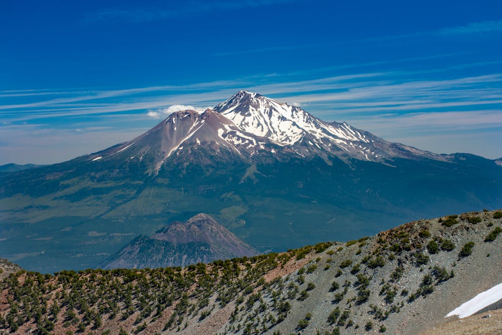
Miles 1501.2-1560.2 of the northbound PCT: A stunning hike beneath granite spires of the Castle Crags, then along miles of panoramic ridge within view of Mount Shasta.
Hiking Moderate

On this first part of Section P northbound, the PCT passes beneath the stately Castle Crags, then climbs to a panoramic crest within a designated wilderness. With views toward Mount Shasta and innumerable lower peaks, the trail wanders the subalpine through remote and rugged territory. Though there are some road crossings later in the segment, all access points are likely to feel very far from anywhere.
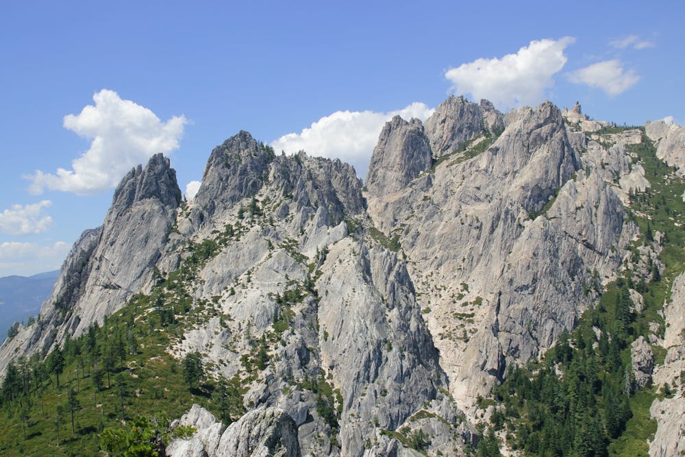
West of Interstate 5, the PCT continues through Castle Crags State Park, among well-watered forest with intermittent views of granite behemoths overhead. It’s quite a pleasant walk among rolling terrain shaded by conifer canopy, crossing several small creeks. Camping is not allowed along the trail within the park, but you could descend one of several side trails to reach the park campground. A better option, however, is to push on through the park and camp in Castle Crags Wilderness to the west.
Upon leaving the state park and entering the national forest (NB mile 1505.5), camping is once again allowed in the usual manner. The PCT continues to dip in and out of forested drainages until crossing Burstarse Creek, where it starts a more significant ascent. In early season, look for Burstarse Falls as the trail switchbacks higher onto the slopes. Soon the trail curves onto the other side of a sparsely treed ridgeline, with phenomenal views of the crags now nearly at eye level.
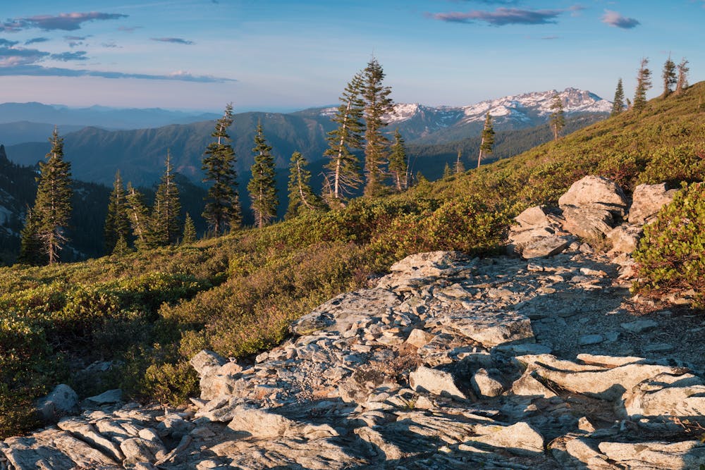
The PCT proceeds on an upward arc into the subalpine, traversing panoramic meadows between stands of conifer. North Fork Spring (NB mile 1515.3) and Gully Spring (NB mile 1516.2) provide chances at water, and small campsites are scattered around, but for the most part, the terrain is sloped and exposed. There are some dry campsites on a ridge (NB mile 1518.9) with absolutely epic views to Castle Crags and also Mount Shasta.
The panoramic walking continues for several miles, and tree-lined lakes become part of the view in basins below. On gradual ups and downs, the trail stays near the crest of the ridge, sometimes in shade but more often in sun-soaked meadows. There is paved road access near Gumboot trailhead (NB 1525.8), which could make a staging area for section hikers. Mt Shasta City is about 16 miles by road, but it’s not a common resupply point.
An excellent place to camp is Deadfall Lakes (NB mile 1536.7), with water and views of surrounding peaks. It’s normally a popular spot but offers room for a few parties to spread out. Not far beyond these lakes, the trail crosses the paved Park Creek Road (NB mile 1539.7) which has another trailhead and a toilet. It makes a decent endpoint for section hikers but is too remote to be handy for resupply.
Beyond Park Creek, The PCT continues through open forest, now on the mountainsides below the crest. It makes several cuts across steep slopes, plus gentler contours around headwater basins. Chilcoot Creek (NB mile 1545.9) holds water seasonally, and has campsites nearby. The remaining water sources along this stretch are all ephemeral, so it could be a long carry in late season.
The end of the segment mapped here is Highway 3 at Scott Mountain Summit (NB mile 1560.2). There is trailhead parking but no water and no facilities. Though the road sees ample traffic, this is not a common spot for distance hikers to leave the trail because it’s still quite far to any resupply. Etna Summit, at the very end of CA Section P (NB mile 1599.7), is a much more convenient access point.
Permits: No permits are needed for hiking and camping along this segment, not even within the Castle Crags Wilderness. Just be aware that backcountry camping is not allowed in Castle Crags State Park. Also, a California campfire permit is required for use of a fire or camp stove anywhere.
Sources: https://hikemtshasta.com/castle-crags/lower-castle-crags-via-pacific-crest-trail/ https://www.fs.usda.gov/recarea/stnf/recarea/?recid=6570 https://www.pcta.org/discover-the-trail/maps/ https://pctmap.net/trail-notes/
Moderate
Hiking along trails with some uneven terrain and small hills. Small rocks and roots may be present.

The trail contains some obstacles such as outcroppings and rock which could cause injury.

Little chance of being seen or helped in case of an accident.
72 routes · Hiking