
72 routes · Hiking
Miles 1016.9-1048.8 of the northbound PCT: Through the stark geology of the Carson-Iceberg Wilderness, to the crossing of a remote highway on the Sierra crest.
Hiking Moderate

This begins CA Section J of the northbound PCT, headed for Echo Lake near Tahoe. The segment here is from Sonora Pass to Ebbetts Pass, a fairly remote and unique section of the trail. It traces the Sierra crest through the Carson-Iceberg Wilderness on a landscape of granite ridges and volcanic peaks that can hold snow well into summer.
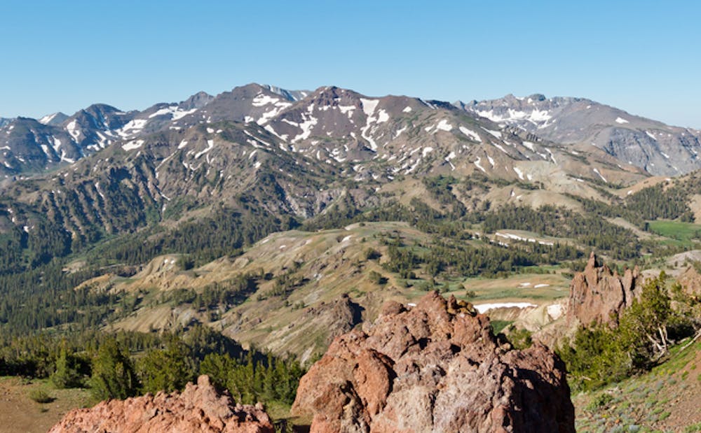
North of Sonora Pass (NB mile 1016.9) is a largely treeless landscape, where the trail twists among fragmented cliffs and slopes of volcanic rock. But it’s splashed with colors of wildflowers, and awash in views over snow-streaked peaks plus the green valleys beneath. This stretch can hold some steep snow crossings, depending on the year.
After rounding a shoulder of Sonora Peak at about 10,500 feet (NB mile 1020), the trail enters pine forest and makes a gradual descent in the East Fork Carson River drainage. Several small streams and good campsites can be found before the trail tips upward again (NB mile 1026.2). It then proceeds to wander among granitic ridgelines, with frequent views through gaps in the forest. One stop of geologic interest is a dome of dark basalt crowning an otherwise white-rock ridge (NB mile 1032.2), clearly showing the volcanic influence on this ancient uplift of granite.
The trail continues to contour along weathered volcanic slopes, taking mild ups and downs between ridgelines. It’s a pattern of curving around one valley, then crossing a mountain gap to the next, all among stark geology and showy subalpine flora. Small streams are generally plentiful, as are places to camp. Lakeside camping can be found at Asa Lake (NB mile 1041.4) and Noble Lake (NB mile 1044). Note that camps must be at least 100 feet away from the water, however.
The end of this segment is at Ebbetts Pass, where the trail crosses State Route 4 (NB mile 1048.8). This is a narrow and winding paved road with generally low traffic, and in a very remote location, making it an uncommon place to enter or exit the trail. With a bit of luck, however, you might hitch westward to Lake Alpine Lodge or the small community of Bear Valley. There is also a PCT trailhead with ample parking nearby (spur trail at NB mile 1048.1), making it feasible for section hikers to start/end here.
Permits: This section is largely within the Carson-Iceberg Wilderness of Stanislaus and Humboldt-Toiyabe national forests. A wilderness permit is required for camping, but the PCT long-distance Permit can serve instead. Campfires are generally allowed (barring any seasonal restrictions) if you have the California campfire permit. Note that regulations for camping, fires, and food storage are different on these forests than on the national forest and national park lands along the PCT to the south. You are responsible for knowing the specifics that apply to where you are.
Sources: https://www.sierrawild.gov/wilderness/carson-iceberg/ https://www.fs.usda.gov/recarea/stanislaus/recarea/?recid=15109 https://pctmap.net/trail-notes/ https://pctwater.com/
Moderate
Hiking along trails with some uneven terrain and small hills. Small rocks and roots may be present.

The trail contains some obstacles such as outcroppings and rock which could cause injury.

Little chance of being seen or helped in case of an accident.
72 routes · Hiking