
72 routes · Hiking
Miles 1655.9-1718.9 of the northbound PCT: The final big climb from a Northern California valley, then along a panoramic ridge to cross into Oregon.
Also in California, United States of America
Hiking Difficult

This section is both California Section R and Oregon Section A of the PCT, crossing finally into the second state along the northbound journey to Canada. It features the last of Northern California’s big climbs out of a river gorge, and the subsequent ridge conveys hikers into the green hills of Oregon. The familiar Interstate 5 marks the end to this section, where it’s common for hikers to leave the trail for celebration and relaxation in Ashland, Oregon, before continuing on.
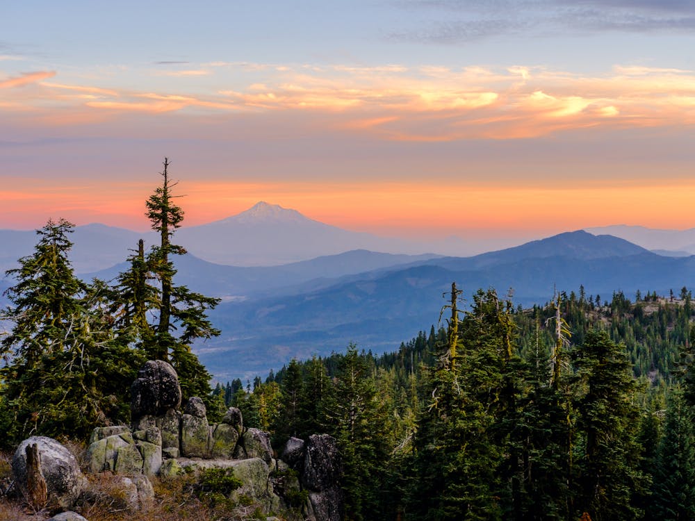
To start the section from Seiad Valley, follow the paved road a short distance out of town until the signed PCT departs into the woods. A big uphill begins immediately, on south-facing slopes that can roast on a sunny day. It’s a devil of a climb, ascending the trio of Lower, Middle, and Upper Devils Peaks in succession. Frequent clearings and burn areas yield rewarding views, however, over Seiad Valley and the Marble Mountains to the south.
There is a campsite with a spring soon after starting the climb (NB mile 1657.6), which could be useful for those with a late departure from Seiad Valley. Another water source called Lookout Spring is farther up (NB mile 1661.9). Past Upper Devils Peak, the panoramic ridgeline leads toward a yet higher summit, but before reaching it, the trail turns and begins to descend, passing another spring (NB mile 1666). The downhill leads eventually to a forest road at Cook and Green Pass, where there’s a good campsite and a piped spring nearby (NB mile 1670.8). Note that you could walk here on Seid Creek Road rather than climbing the Devils Peaks, and that makes a rather popular alternative in hot weather.
From the pass, the trail goes uphill again, but less aggressively this time. Largely among skeleton forest and subalpine meadows, it remains a weather-exposed walk with big views. Water can be found at Bear Dog Spring (NB mile 1676.2), and after that, the trail enters mature forest interspersed with vibrant meadows. The trail continues to meander along a broad ridge, alternating from trees to clearings with no major ups or downs for several miles. Springs continue to be somewhat common, and most are marked by signs along the trail.
These miles are aesthetically pleasing on a clear day but do not feel especially remote. Dirt road crossings are frequent, and there’s a big junction at Wards Fork Gap (NB mile 1689.1). Traffic is always light, however, and you’re likely to encounter far more hikers on the trail than vehicles on the roads. Before long, you’ll arrive at the California/Oregon border––an unassuming spot on a forest edge but marked with a wooden sign. This is northbound mile 1692, give or take, with about 960 miles left to Canada. It’s a truly momentous mile marker for south-north thru-hikers, who have likely spent more than 100 days in one state thus far.
Shortly after the state line, the trail crosses a dirt road that’s occasionally the site of some generous trail magic (NB mile 1692). From there, the trail continues mostly uphill, with frequent views down to meadowy valleys and across to rows of mountains. Dirt roads continue to be present like before, as do small springs and now seasonal creeks added to the mix. A good camp is at Sheep Camp Spring (NB mile 1696.1) near Observation Peak.
The remaining miles to Interstate 5 bring the trail into higher elevations, with rockier slopes and sparser forest, but the tread remains generally smooth. Mount Ashland provides one possible access point, where there’s a paved road crossing with a Forest Service campground nearby (NB mile 1711.6). For the next several miles, the trail contours through the forest above this road, heading generally downhill to eventually meet the interstate (NB mile 1718.7).
Callahan’s Lodge is at a nearby interstate exit and can be reached by a side trail (NB mile 1717.7) a mile before the PCT reaches the road. The lodge offers resort-style accommodations but also reasonably priced amenities for hikers. Then there is the city of Ashland, which makes a very common off-trail stopover for rest and resupply. It lies about 13 miles north along the interstate.
Permits: No permits are needed for hiking or camping on this section of the PCT, which goes through Klamath and Rogue River national forests. As the final section in California, however, you will likely need the CA campfire permit for use of a fire or stove.
Sources: https://www.pcta.org/discover-the-trail/maps/ https://pctmap.net/trail-notes/
Difficult
Hiking trails where obstacles such as rocks or roots are prevalent. Some obstacles can require care to step over or around. At times, the trail can be worn and eroded. The grade of the trail is generally quite steep, and can often lead to strenuous hiking.

The trail contains some obstacles such as outcroppings and rock which could cause injury.
Away from help but easily accessed.
72 routes · Hiking