5.6 km away
Sulphur Creek Canyon
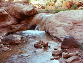
Wade and scramble through the twisting narrows of a deep canyon flowing with cold water.
Severe Hiking
- Distance
- 9 km
- Ascent
- 46 m
- Descent
- 227 m
A backcountry route for seasoned desert hikers, potentially linking with the more popular Lower Spring Canyon.
Hiking Severe

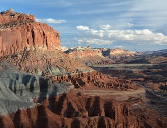
Spring Canyon is a long, deep gorge in the northern part of Capitol Reef National Park, carving deep into layers of red Wingate and white Navajo sandstones. Among all the canyons in Capitol Reef, Spring is one of the most extensive and impressive. However, this canyon does not have any designated trails within it, so it gets overlooked on most park maps. Hiking in the wash through the canyon bottom is the way to go, but it takes some work just to get into it.
Upper Spring Canyon is the section mapped here. There’s also Lower Spring Canyon, which is better known and easier to access. Upper Spring is kind of a no man’s land, only for the savviest desert hikers to explore. Chimney Rock Canyon is the divider between Upper and Lower Spring and makes a straightforward exit/entrance route. It’s the upper end of Upper Spring Canyon that is difficult to access. The route is cross-country over complex terrain, requiring map navigation and route finding skills to negotiate cliff-lined washes, boulder jumbles, and open desert. Once in the canyon, it’s a rather straightforward hike down the wash, but still with some dry falls and cliff bands to work around. No ropes or other technical gear are required.
Most people do Upper Spring Canyon top-down as mapped here, starting at Holt Draw and exiting at Chimney Rock Canyon. This is doable as a long day hike but is perhaps better broken into an overnight backpacking trip. It could, of course, be extended through Lower Spring Canyon as a multi-day trip as well. You will need to stage a vehicle or bike shuttle or try to hitch a ride to get back to your car at Holt Draw.
The only water source in this canyon is a spring that’s about a mile and a half above the junction with Chimney Rock Canyon, making that vicinity the most desirable place to camp. The Park Service states that even this spring may be unreliable, however, so you’ll want to carry extra water. No permit is required to do this as a day hike, but you will need a backcountry permit for backpacking.
Sources: https://www.nps.gov/care/planyourvisit/springcanyon.htm https://liveandlethike.com/2015/03/23/upper-spring-canyon-capitol-reef-national-park-ut/
Severe
Hiking challenging trails where simple scrambling, with the occasional use of the hands, is a distinct possibility. The trails are often filled with all manner of obstacles both small and large, and the hills are very steep. Obstacles and challenges are often unexpected and can be unpredictable.

Some trail sections have exposed ledges or steep ascents/descents where falling could cause serious injury.

In the high mountains or remote conditions, all individuals must be completely autonomous in every situation.
5.6 km away
Wade and scramble through the twisting narrows of a deep canyon flowing with cold water.
Severe Hiking
6 km away
A day or overnight hike through a canyon of colossal proportions, buried in the backcountry of the national park.
Difficult Hiking
8 routes · Hiking
5 routes · Hiking