14 m away
Cole Mountain Loop
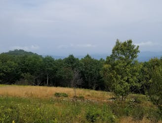
An epic hike off of the Appalachian Trail with astonishing views atop Cole Mountain.
Moderate Hiking
- Distance
- 9.4 km
- Ascent
- 413 m
- Descent
- 413 m
A phenomenal hike through the Virginia Blue Ridge with incredible views atop Mount Pleasant.
Hiking Difficult

Whether you are looking for a day hike or an overnight trip, the views atop Mount Pleasant are well worth the trip. Combined with the nearby Appalachian Trail, this area is one of the most underrated hiking areas in Virginia.
This loop begins at a small trailhead just off of Wiggins Spring Road. Cell reception is extremely limited and should not be relied upon for any reason. Plan accordingly and make sure to tell someone of your plan and when you expect to return. Additionally, the gravel road to the trailhead is particularly rough and a higher-clearance vehicle is recommended.
According to hikingupward.com, the trail is meticulously maintained by the local Appalachian Trail Club, NBATC. Evidence of the work is particularly evident near the summit of Mount Pleasant.
This loop can be hiked in either direction, or as an out-and-back to Mount Pleasant. Two vistas can be found at the summit, one to the east and the other to the west. The exposed, craggy clearings provide spectacular views from their perch. The western summit also hosts two small campsites, though the peak is known to experience stronger than normal winds. To some, this could be the perfect opportunity to prepare for a longer or higher-elevation backpacking trip.
There is a seasonal spring on the loop, and other camping opportunities along the eastern portion of the loop. Should you be able to find it, a small unmarked trail leads to another vista atop Pompey Mountain where you can snag more views to the northeast.
For extra miles, this loop is often paired with the adjacent Cole Mountain Loop, where you'll pass through a high bald meadow with views that rival those of the Roan Highlands.
Difficult
Hiking trails where obstacles such as rocks or roots are prevalent. Some obstacles can require care to step over or around. At times, the trail can be worn and eroded. The grade of the trail is generally quite steep, and can often lead to strenuous hiking.

The trail contains some obstacles such as outcroppings and rock which could cause injury.

Little chance of being seen or helped in case of an accident.
14 m away
An epic hike off of the Appalachian Trail with astonishing views atop Cole Mountain.
Moderate Hiking