
72 routes · Hiking
Miles 2464.1-2571.9 of the northbound PCT: A long expanse through the Glacier Peak Wilderness, centered on Washington's most isolated stratovolcano.
Hiking Difficult

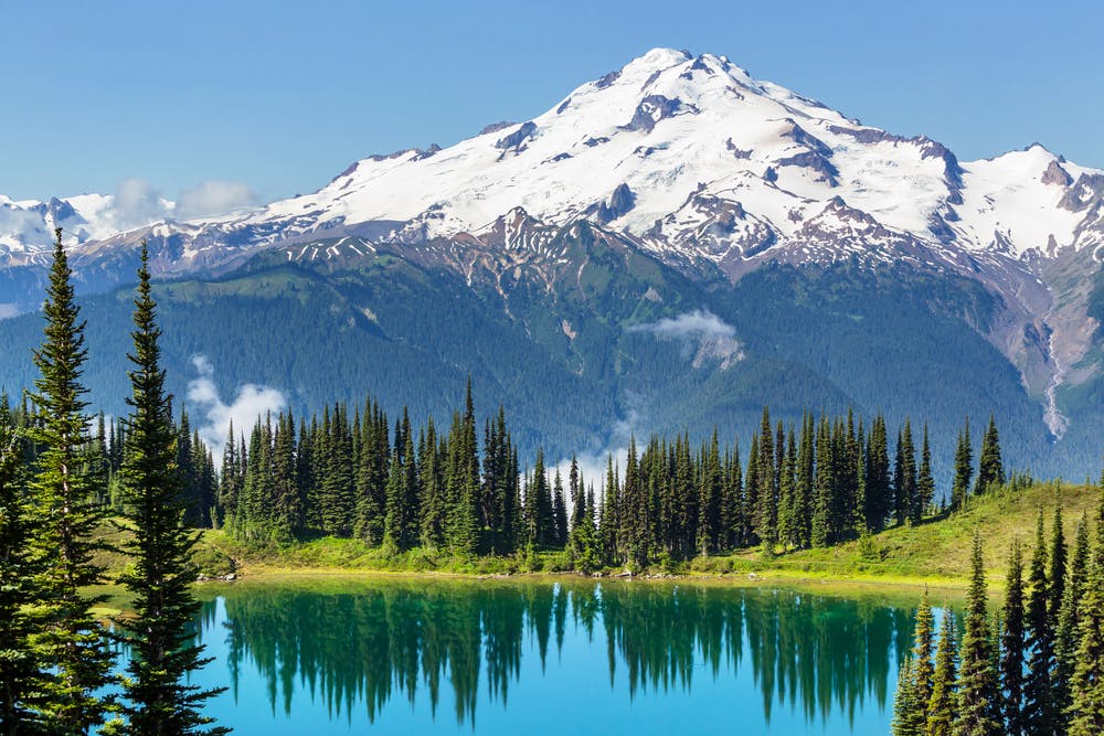
Here the trail delves quite deep into the Cascades, on a procession of ridgelines surrounding Glacier Peak––the most remote of Washington’s major volcanoes. On repeated ups and downs between epic views and sheltered valleys, the trail journeys around the flank of this majestic, ice-covered mountain. You must hope for good weather in order to reap the views, however. Northbound thru-hikers, or anyone attempting Washington in late season, are often plagued with the notorious fog and rain. Mid-summer is typically best for scenery and most comfortable conditions, though snow can linger late at the upper elevations.
Embarking on this long segment requires considerable preparation and commitment. It’s more than 100 miles of trail through two contiguous wilderness areas. A study of the map will reveal connecting trails which section hikers can use to make loops, but remote trailheads make these impractical for thru-hikers to leave the trail. Even the end of the segment at High Bridge is quite isolated, with limited and seasonal access. Therefore, many hikers visit Skykomish to stock up before heading north from Steven Pass.
From the trailhead at Stevens Pass (NB mile 2464.2), the PCT heads uphill and soon enters the Henry M. Jackson Wilderness (NB mile 2467.5). The first highlight here is Lake Valhalla, which sits below the trail against a backdrop of vertical cliffs. Camping is an option near the creek above the lake or at spots down by the shore (NB mile 2469.8). Next, the trail tops a pass and begins to descend.
It’s a gradual downhill through forest and brushy clearings to eventually reach Lake Janus (NB mile 2470), which has established campsites and a pit toilet. The trail turns uphill once more, but the climb out of this valley is brief compared to most in Washington’s Cascades, and instead of another descent immediately following, the trail strides along a ridge to Grizzly Peak. With views of white-clad Glacier Peak on the horizon and glistening lakes below, the trail winds through colorful foliage on the Cascade Crest.
You’ll want to pause and admire the horizon of mountains on top of Grizzly (NB mile 2478.6), then you’ll proceed along an equally panoramic ridge before the trail drops down again, soon reaching a minor pass (NB mile 2481.2). On the proceeding uphill, good camping can be found at Pear Lake (NB mile 2482.6). It’s not long before the trail meets the crest once more, crossing some boulder-strewn slopes to get there. The remaining miles in the Henry M. Jackson Wilderness more or less follow a continual spine of mountains, with constant ups and downs but no major elevation changes.
When the trail dips down to Pass Creek (NB 2489.2) there is a good option for camping with a toilet. From there, the trail goes up to traverse expansive meadows on the side of Skykomish Peak and soon reaches spectacular camping with established sites at Lake Sally Ann (NB mile 2493.5), which is tucked into an alpine bowl at the head of a glacial valley. Continuing along rolling ridgetops and grassy slopes, the trail finds breathtaking views above the timberline with Glacier Peak looming ahead. Soon it crosses into the Glacier Peak Wilderness (NB mile 2496.9), and continues along a skyline divide with huge valleys stretching away on either side. For camping or water along this section, you might stop at Reflection Pond (NB mile 2500.2) or drop down a side trail at White Pass (NB mile 2502).
Next, the trail traverses the west face of White Mountain, then doubles back to cross over the ridge and begin a significant descent (NB mile 2503.8). It curves through a largely barren valley, where snow can linger late into the summer. But soon enough, squat conifers appear, followed by thick forest that gets lusher with lessening elevation. Small creek crossings lead up to the White Chuck River (NB mile 2507.7), which is spanned by a bridge. By now, the surroundings are dense temperate rainforest fed by frequent rain and the runoff from Glacier Peak overhead.
Sure enough, the uphill resumes, but gradually at first. The trail crosses several more small streams, mostly with the aid of footbridges. Kennedy Creek (NB mile 2512.3) is a bit larger, and usually flows silty with glacial flour. After this crossing, the climb steepens, and the trail rises once again to open meadows near the timberline. A zigzagging ascent takes the trail over another major divide, then it drops quickly down to Mica Lake (NB mile 2520.7). Spectacular but somewhat exposed camping can be found near the shore.
The next stretch of trail makes a pattern of punishing downs and ups. First, a ton of switchbacks drop into the gorge of Milk Creek. Then after crossing the stream on a bridge (NB mile 2524.6), just as many switchbacks climb immediately out again. The consolation is a view toward glaciers on the mountain, but only if the clouds allow. At the top of the climb (NB mile 2529) is a welcome flat section with some campsites scattered along. Here the trail contours around the head of another steep valley, but the next big descent is not far away. After crossing the next ridgeline (NB mile 2530.8), the trail begins its long descent to the Suiattle River.
Many switchbacks lead downward through forest and avalanche clearings to a cluster of campsites near Vista Creek (NB mile 2535.2). From there, it’s more downhill through lush forest of the creek valley, eventually joining the Suiattle River. Here the PCT takes a frustratingly inefficient course, turning to follow the river 3 miles downstream before crossing on a bridge (NB mile 2540.6) then returning 4 miles upstream. One redeeming quality is the impressive old-growth along the way, with some truly huge trees presiding over the trail.
Finally leaving the Suiattle River behind, the trail ascends through continual forest in an adjacent valley, where streams and campsites are plentiful. Eventually, the incline steepens to get over a pass (NB mile 2552), where gaps in the trees grant a final view of majestic Glacier Peak. Just over the other side is a possible campsite in a meadow with a stream (NB mile 2552.4). From there, what remains is essentially a long valley walk to reach the Stehekin River.
To start the descent, the trail bends in and out of a glacial cirque, where water rushes among the talus and a campsite can be found (NB mile 2553.9). After curving around a sparsely forested mountainside, the trail enters another cirque––bigger and even more dramatic than the first. The vertical granite of Sitting Bull Mountain rises overhead. Some established campsites can be found here as well (NB mile 2557.1). The continued descent leads into the deep U-shaped valley below, which is streaked with avalanche meadows spilling from rock-bound chutes above. Moving down, the forest becomes lusher, and creeks must be forded or hopped across. Camps are scattered along, but Swamp Creek (NB mile 2563.8) and Pass Creek (NB mile 2566.8) are particularly good.
The long woods walk eventually culminates at the boundary of North Cascades National Park, where the trail crosses Agnes Creek on a bridge (NB mile 2571.6). There’s a beautiful view of the road bridge over a whitewater box canyon, before the trail joins that road and crosses over the river (NB mile 2571.9). On the other side is a ranger station and shuttle stop. The Stehekin Shuttle operates early May through mid-October, traveling between High Bridge and Stehekin Landing. By shuttle you can get to Stehekin Valley Ranch or the village of Stehekin on Lake Chelan. The village has a campground, post office, small shops, and a bakery that hikers rave about. There is also a NPS visitor center that issues backcountry permits for North Cascades.
Permits: This segment does not require any permit, but hikers should sign in at trail registers where they occur. Those beginning from Forest Service trailheads may need a Northwest Forest Pass or equivalent for parking. Anyone planning to camp in North Cascades National park along the next segment to the north will need a permit arranged with the park in advance.
Sources: https://www.wta.org/go-hiking/hikes/lake-janus-grizzly-peak https://www.fs.usda.gov/recarea/mbs/recarea/?recid=79419 https://www.pcta.org/discover-the-trail/maps/ https://pctmap.net/trail-notes/
Difficult
Hiking trails where obstacles such as rocks or roots are prevalent. Some obstacles can require care to step over or around. At times, the trail can be worn and eroded. The grade of the trail is generally quite steep, and can often lead to strenuous hiking.

Some trail sections have exposed ledges or steep ascents/descents where falling could cause serious injury.
Little chance of being seen or helped in case of an accident.
72 routes · Hiking