


+ 194
Mount Kilimanjaro: Machame Route (Whiskey Route Kili Kilimanjaro Mount Kilimanjaro)
Hiking Trail
Hard
35.31 mi
17,003 ft
Route to the roof of Africa—popular for its aesthetic quality and high success rate.
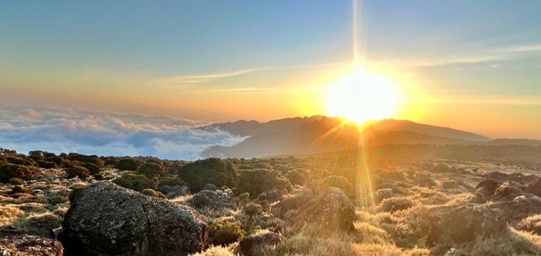
Mount Kilimanjaro in Tanzania is Africa’s highest point, the world’s highest free-standing mountain, and one of the most sought-after summits on the planet. A massive volcano soaring to 5,895 meters elevation, its summit conjures snow and glaciers high above East Africa’s sunny equatorial plains. Its slopes support an environment isolated in the sky, where snowmelt waters tropical rainforest, alien-like flora clings to a frosty moonscape, and seas of clouds roll below.
Reaching the roof of Africa is no easy feat, but it's achievable for beginning mountaineers with proper guidance. Physicality of the steep trails as well as altitude sickness defeat many trekkers, so attention to route and itinerary are crucial for safety. Machame is one of several standard routes up the mountain, and may be the all-around best for aesthetics and success rate. It is not the least steep nor the shortest route, but the terrain is conducive to gradual acclimatization, so risk of elevation sickness is minimized.
All climbs require a guide, per regulations of the national park, but you can choose your service based on the route and schedule you wish to follow. Machame is typically completed (to the top and back down) in 6-8 days. Accommodations are tents or huts provided by the guides. Meals and other services are provided as well. Machame Route is highly recommended for first-timers to Kilimanjaro, and has therefore become the most popular option in recent years (though it is only slightly more popular than Marangu Route).
It begins from Machame Village, climbs to Lava Tower, then traverses via the Southern Circuit to Barafu and the final push to Uhuru Peak. The descent is back to Barafu and then down Mweka Trail.
The first day’s trek leads through rainforest, on a slippery trail under hanging vines and huge leaves. The lush vegetation thins as you get higher, and soon gives way to the grasses and shrubs of the moorlands, where cooler temperatures and drier air prevail. The terrain only gets wilder as you continue upward.
The wide open Shira Plateau is a rock-strewn desert nearly devoid of life, granting expansive views in all directions. Looming above is the snowy peak of the mountain. Camp on this natural balcony overlooking the world below, and adjust to the altitude. The next day leads up to more sky-high vistas from Shira Camp. From there the climb continues upward through the volcanic landscape to Lava Tower, an especially large lava dome protruding from the mountainside.
Round the flank of Lava Tower to begin hiking downhill, into Barranco Canyon. Here waterfalls and wildflowers line the walls, and the bizarre branches of giant groundsel trees tower overhead.
After Barranco Camp comes the intimidating Barranco Wall, a scramble with hands and feet to top out the canyon. This begins the long traverse of the Southern Circuit, which rewards all along with views of the Tanzanian savannah spilling away below.
After a day or two crossing the traverse and continuing to acclimatize, Barafu Camp marks the beginning of the summit push. Summit day requires a midnight start, so as to take on the steep switchbacks and loose scree while the ground is more solid due to being frozen before dawn. A well-timed ascent greets sunrise on top of Uhuru, the high point of Africa. From there the route reverses to Barafu and continues down the Mweka Trail efficiently to the foot of the mountain.
Sources:
Written by Jesse Weber
Created By
Strava Routes
