175 m away
Pizzo Cefalone da Campo Imperatore
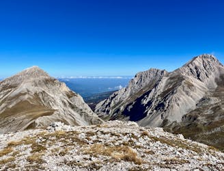
An easily-accessible hike to a beautiful mountain peak.
Extreme Hiking
- Distance
- 8.3 km
- Ascent
- 524 m
- Descent
- 524 m
Itinerario andata e ritorno per la vetta più alta dell'appennino italiano, il Corno Grande
Also in L'Aquila, Italy
Hiking Severe

This is a popular hiking route which is generally considered to be severe. It's very remote, it features high exposure and is typically done between May and September. From a low point of 2.2 km to the maximum altitude of 2.9 km, the route covers 5.5 km, 784 vertical metres of ascent and 51 vertical metres of descent.
Partenza dal parcheggio dell'Albergo di Campo Imperatore è un itinerario accessibile per i circa i 4/5 del percorso, il percorso diventa più ostico solo nella parte finale della salita alla vetta.
Severe
Hiking challenging trails where simple scrambling, with the occasional use of the hands, is a distinct possibility. The trails are often filled with all manner of obstacles both small and large, and the hills are very steep. Obstacles and challenges are often unexpected and can be unpredictable.

Some trail sections have exposed ledges or steep ascents/descents where falling could cause serious injury.
Little chance of being seen or helped in case of an accident.
175 m away
An easily-accessible hike to a beautiful mountain peak.
Extreme Hiking