The Larapinta Trail
One of the most popular multi-day hikes in Australia, the Larapinta Trail is a challenging, remote hike from Alice Springs to Mount Sonder taking in a variety of breathtaking views.
Hiking Extreme
- Distance
- 234 km
- Ascent
- 5.1 km
- Descent
- 4.9 km
- Duration
- 1 day +
- Low Point
- 590 m
- High Point
- 1.3 km
- Gradient
- 9˚

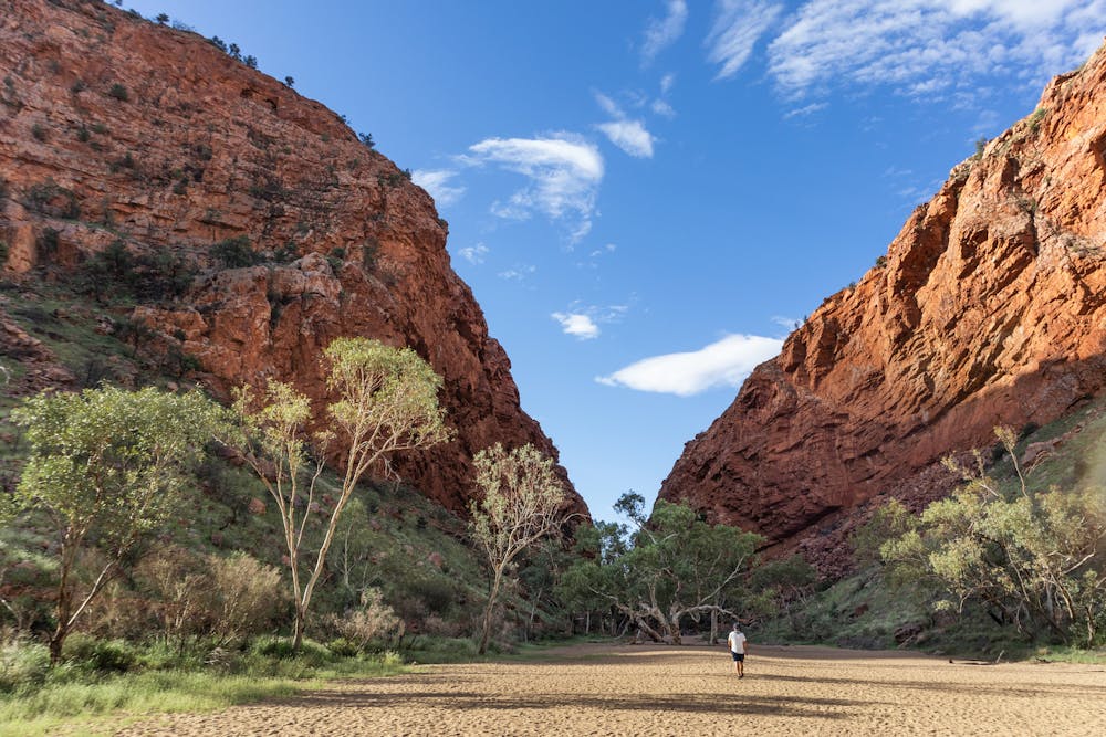
The Larapinta Trail is a 233km / 144-mile long-distance walking trail in Australia's Northern Territory. It follows the West MacDonnell Ranges, which are a series of rugged mountain ranges that stretch westward from Alice Springs. The trail passes through some of the most stunning and remote landscapes in Australia, including red sand dunes, rocky gorges, and ancient rock formations. It is considered one of the best and most challenging multi-day hikes in the Southern Hemisphere.
Description
The Trail can be hiked in its entirety or in sections, and it is usually completed in between 12-14 days in a single direction (hikers going from Alice Springs to Mount Sonder need to organise a transfer in advance). Although the trail is well-marked and has designated campsites along the way, it is classified as a "remote area hike", meaning that hikers need to be entirely self-sufficient and prepared for the rugged and isolated conditions. It is recommended that independent hikers are both well-versed in bush walking, and have a high level of fitness as the trail includes some steep and challenging sections.
The Larapinta Trail is best hiked during the cooler months of the year, from April to October. During the summer months, temperatures can reach up to 40 degrees Celsius / 104 degrees Fahrenheit, and there is a risk of bushfires.
The trail is also home to a variety of wildlife, including kangaroos, wallabies, goannas, and many species of birds. It is a unique and rewarding experience for hikers looking to explore the beauty and isolation of the Australian outback.
The Larapinta Trail is a popular destination for hikers, and it offers a unique opportunity to experience the natural beauty of the Australian outback. Many people choose to walk the trail as part of a guided tour, which provides support and expertise for the journey. Alternatively, hikers can choose to walk the trail independently, using a variety of accommodation options, including campsites, hostels, and hotels.
The twelve sections of the Larapinta Trail: Section 1: Alice Springs Telegraph Station to Simpsons Gap (Distance: 24.7km / circa 9 hours). Section 2: Simpsons Gap to Jay Creek (Distance: 26.2km / circa 8.5 hours) Section 3: Jay Creek to Standley Chasm (Distance: 13.6km / circa 5.5 hours) Section 4: Standley Chasm to Birthday Waterhole (Distance: 17.9km / circa 8.5 hours) Section 5: Birthday Waterhole to Hugh Gorge (Distance: 14.9km / circa 9.5 hours) Section 6: Hugh Gorge to Ellery Creek North (Distance: 28.9km / circa 10.5 hours) Section 7: Ellery Creek North to Serpentine Gorge (Distance: 12.8km / circa 5 hours) Section 8: Serpentine Gorge to Serpentine Chalet Dam (Distance: 13km / circa 5.5 hours) Section 9: Serpentine Chalet Dam to Ormiston Gorge (Distance: 28.3km / circa 12 hours) Section 10: Ormiston Gorge to Finke River (Distance: 9.1km / circa 4 hours) Section 11: Finke River to Redbank Gorge Distance: 26.3km / circa 9.5 hours) Section 12: Redbank Gorge to Mt Sonder return (Distance: 15km / circa 6 hours)
Difficulty
Extreme
Scrambling up mountains and along technical trails with moderate fall exposure. Handholds are necessary to navigate the trail in its entirety, although they are not necessary at all times. Some obstacles can be very large and difficult to navigate, and the grades can often be near-vertical. The challenge of the trail and the steepness of the grade results in very strenuous hiking. Hikes of this difficulty blur the lines between "hiking" and "climbing".
Remoteness

In the high mountains or remote conditions, all individuals must be completely autonomous in every situation.
Best time to visit
Features
- Historical
- Picturesque
- Summit Hike
- Forestry or heavy vegetation