99 m away
Boroka Lookout from Halls Gap
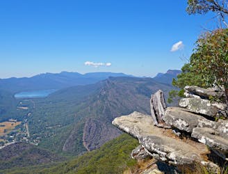
A challenging climb through the bush to one of the best lookouts in the Grampians.
Difficult Hiking
- Distance
- 12 km
- Ascent
- 769 m
- Descent
- 769 m
A challenging multi-day hike that takes in some of the most spectacular vistas in the Grampians - and promises plenty of wildlife-spotting opportunities.
Hiking Difficult

The Central Grampians Loop - part of the larger Grampians Peak Trail - is a 36-kilometer circuit that explores one of the most scenic locations in the Grampians National Park. It is recommended to allow around 3 days to complete the circuit, but it is possible to do it faster if maintaining a steady pace.
Hikers on this route will be treated to spectacular vistas and are likely to come across plenty of native wildlife, including kangaroos and emus.
There are several entry points along the trail and a number of campsites along the route. Even though there are water stations, make sure you have enough water and supplies before you begin. The area has been affected by bush fires in recent years so check trail conditions before departure.
Difficult
Hiking trails where obstacles such as rocks or roots are prevalent. Some obstacles can require care to step over or around. At times, the trail can be worn and eroded. The grade of the trail is generally quite steep, and can often lead to strenuous hiking.

Little chance of being seen or helped in case of an accident.
99 m away
A challenging climb through the bush to one of the best lookouts in the Grampians.
Difficult Hiking