BergeSeen Trail Etappe 04: St. Wolfgang - Mondsee
Guided tour: St. Wolfgang - Schafbergalm (Schafberg summit) - Krotensee - Almkogel - Mondseeh
Also in Salzburg, Austria
Hiking Difficult
- Distance
- 22 km
- Ascent
- 1.3 km
- Descent
- 1.4 km
- Duration
- 6-7 hrs
- Low Point
- 480 m
- High Point
- 1.3 km
- Gradient
- 21˚

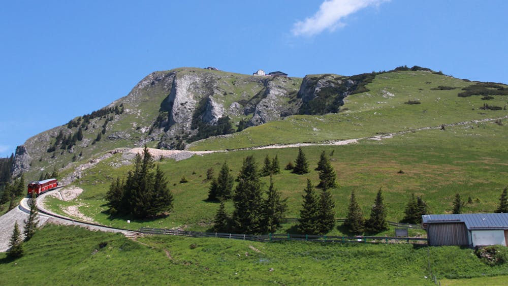
From St. Wolfgang to the Schafbergalm (2 hours)From the starting point of the tourist office in St. Wolfgang, which is located at the eastern portal of the St. Wolfgang bypass tunnel, the road quickly leads to the market square in front of the pilgrimage church. At the beginning of the market square (signpost), turn right through the Florianigasse, then over the Kalvarienbergweg to the first chapel. To the left of it over steps up, at a turn-off again to the left and over the shady Malersteig on a hill and in the consequence down over steps to a crossing. On the mountain road up 50 meters, then left on a path to the Dittlbach (border between Upper Austria and Salzburg) and beyond the stream up to the snack station Aschinger. Here begins the wide Schafbergweg, which leads partly steeply to the beautifully situated Dorneralm. Further the path through the forest leads always ascending to the beginning of the Schafbergalm (signpost). Once up here, you have not only reached the highest point (1300 m), but also the most beautiful point of this stage, the Schafbergalm, which can also be reached by rack railway from St. Wolfgang. Hikers who have stayed overnight at the Schafberg summit need about an hour to get there when hiking downhill along the particularly panoramic trail.From the Schafbergalm to the Krotensee (2 hours)The hiking trail now leads downhill to the village of Winkl. First briefly on the forest road, then right through the forest, crossing the forest road twice. From the first house (on the road) in Winkl a short distance further, then sharp right and to a road barrier. Before you get there, turn left and follow the narrow path over to Gasthof Batzenhäusl and the picturesque Krotensee. From Krotensee via Almkogel to Mondsee (4 hours)Now the ascent to Almkogel begins. From the Krotensee you walk on a narrow road between meadows down to the farm Zeppezau, then along the brook uphill, past a former mill to a turnoff, here straight on, past a new chapel worth seeing to an alpine meadow, then right on a narrow path up to a mountain ridge. The trail continues along a forest path uphill for some time and finally reaches a signpost over a narrow path. From here you can climb the rocky summit of Almkogel (1,030 m) in a very short time. A splendid view of the Attersee, Moonsee and Irrsee lakes rewards this short effort: from the summit back to the signpost, then the trail leads right through the steep forest down to the Thekla Chapel, from where it is not far to the Drachenwand Inn. Now the mountains are overcome and a flat hike to Mondsee follows, first on the road to the beautiful twin-towered church of St. Lorenz, then on a narrow road to the main road, which is crossed. Beyond on a road to the shore of the Mondsee and through the settlement of Schwarzindien, followed by an avenue, then you have to walk a short distance beside the main road until you can turn right to the shore of the lake. The centre of the village is reached from the beautiful promenade along the Lindenallee.
Difficulty
Difficult
Hiking trails where obstacles such as rocks or roots are prevalent. Some obstacles can require care to step over or around. At times, the trail can be worn and eroded. The grade of the trail is generally quite steep, and can often lead to strenuous hiking.