7.8 km away
Big Sister | C'est Notre Monde
A steep scramble to a mythical summit in the Canadian Rockies
Extreme Hiking
- Distance
- 5.5 km
- Ascent
- 1.2 km
- Descent
- 1.2 km
Conquering Great Heights: Ascending Mount Sparrowhawk's Iconic Route
Hiking Difficult

VIDEO: https://youtu.be/5M2URz1BZsI
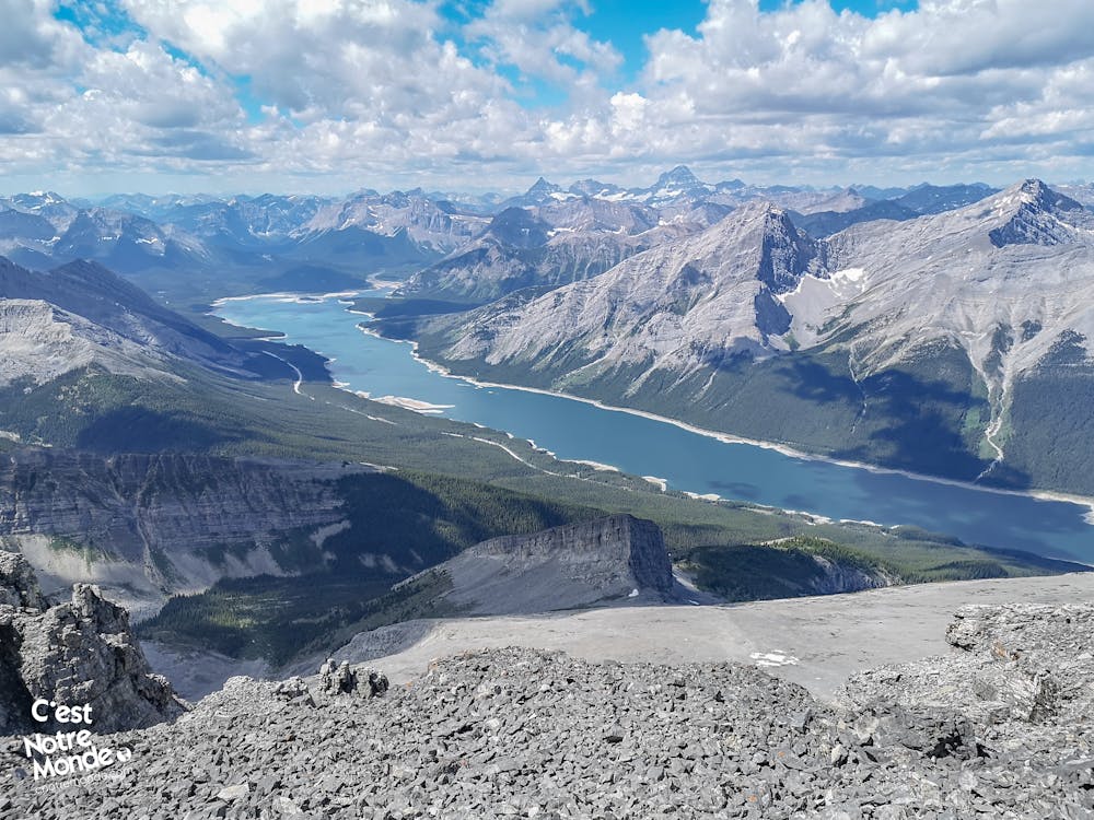
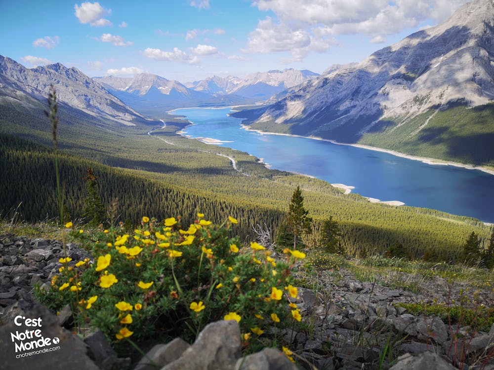
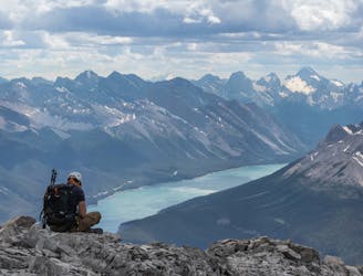
ENGLISH https://www.cnotremonde.com/en/itineraries/alberta-en/mount-sparrowhawk/ Discover our first ascent of over 3000m in the Canadian Rockies: Mount Sparrowhawk! This mountain holds a special place in our adventure. The climb to its 3121m (10,240ft) summit is a challenging yet achievable feat, requiring no advanced technical skills. Through forests and scree fields, the views are breathtaking, offering a stunning panorama of the Spray Lake Reservoir and the imposing peaks of Kananaskis Country. An experience of easy scrambling to add to your list of unforgettable hikes!
DIRECTIONS Embark on the exhilarating journey to summit Mount Sparrowhawk, starting from the "Sparrowhawk Day Use Area" parking lot. Access the prominent "Read’s Tower Route" trail, clearly marked across Highway 742. After a 400m (0.25mi) walk, turn left at the initial junction. The first 1.3km (0.8mi) of the trail winds through a forest, with varying terrain and some less defined sections. Navigate with ease by spotting the orange ribbons tied to trees.
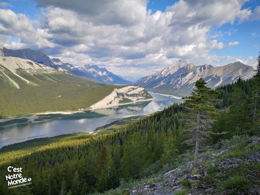
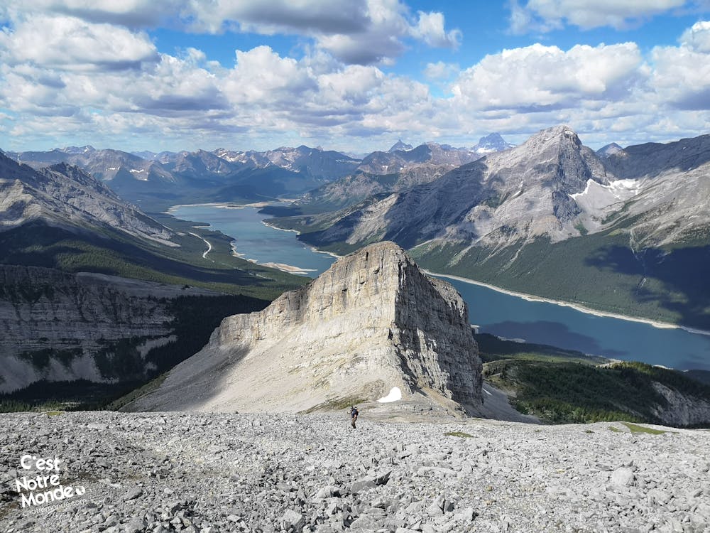
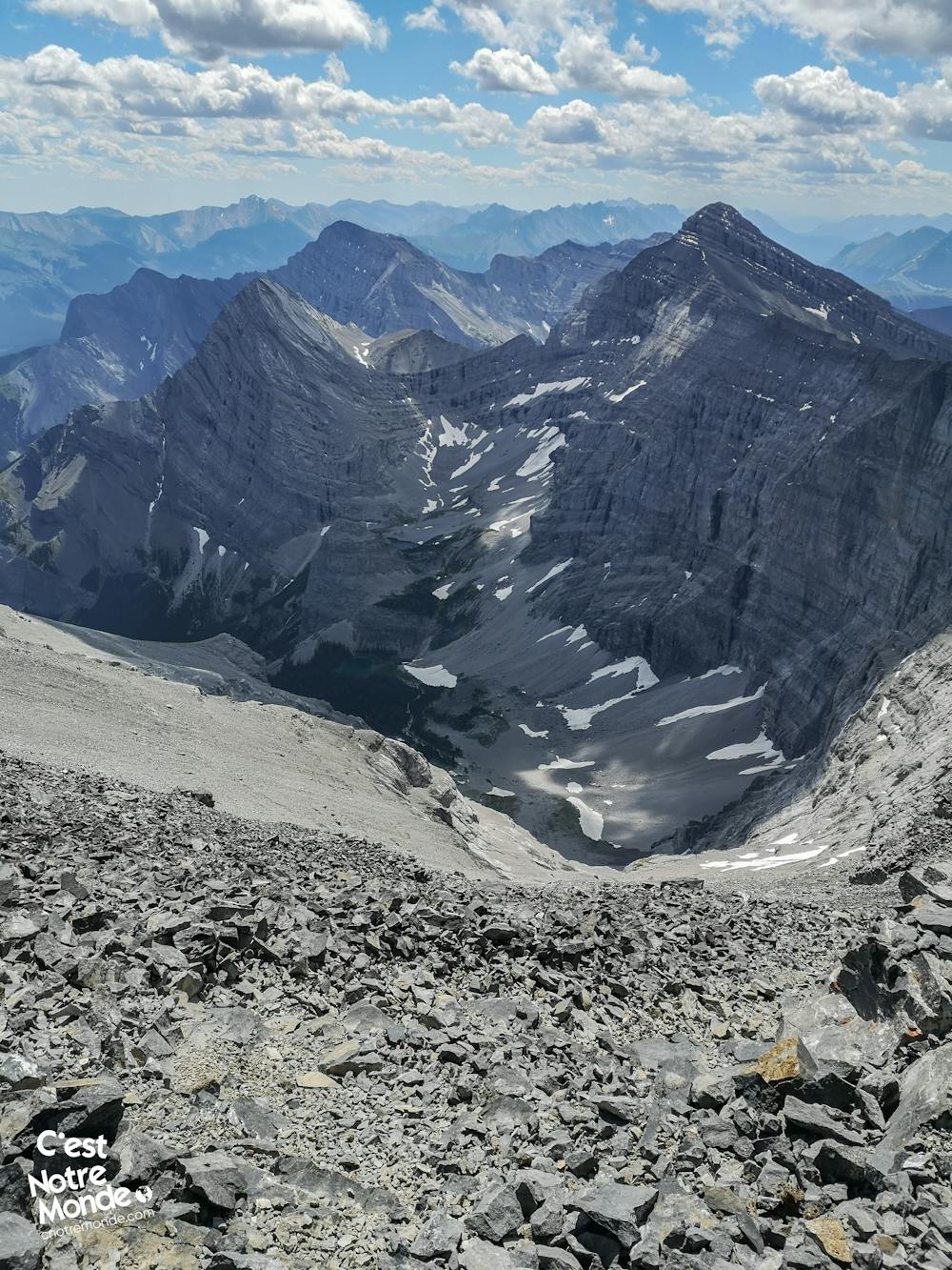
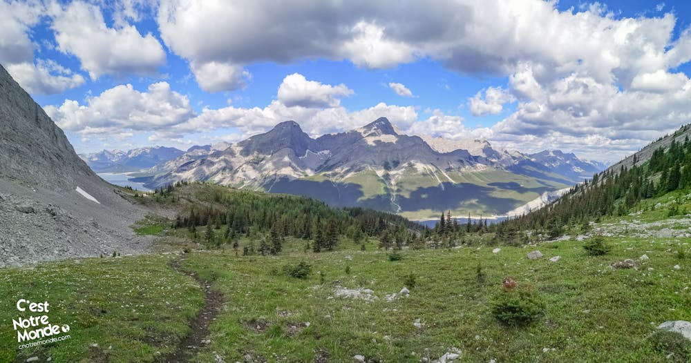
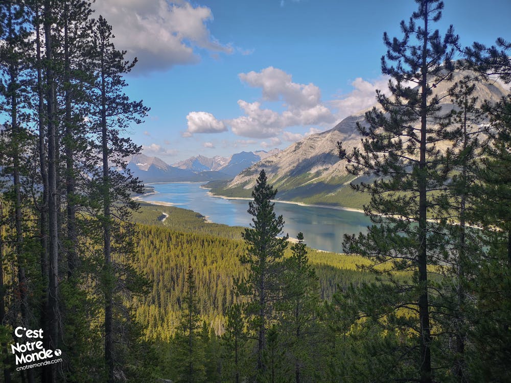
Exiting the forest reveals the breathtaking sight of the turquoise waters of Spray Lake. Follow the trail to a critical intersection. Opt to turn left, as the right path leads to the nearby summit of Read’s Tower (2657m / 2717ft). Look for a small cairn marking this intersection. The trail then skirts the imposing cliffs of Read’s Tower, eventually reaching a small cirque. Prepare for scrambling as you exit the cirque and ascend to a col with a stunning view of Mount Sparrowhawk.
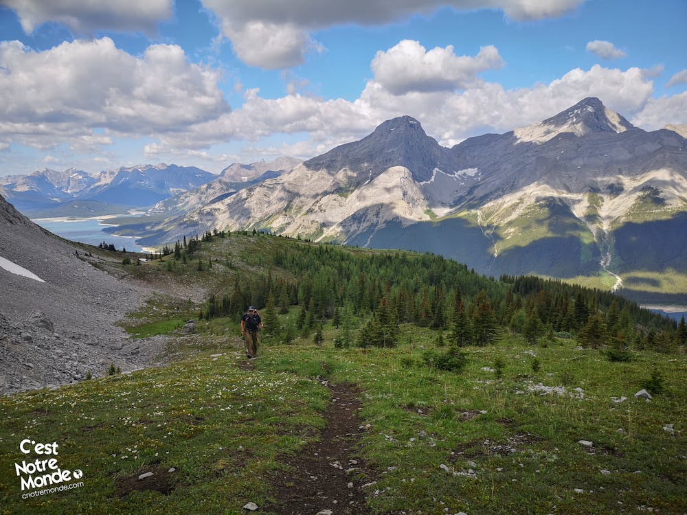
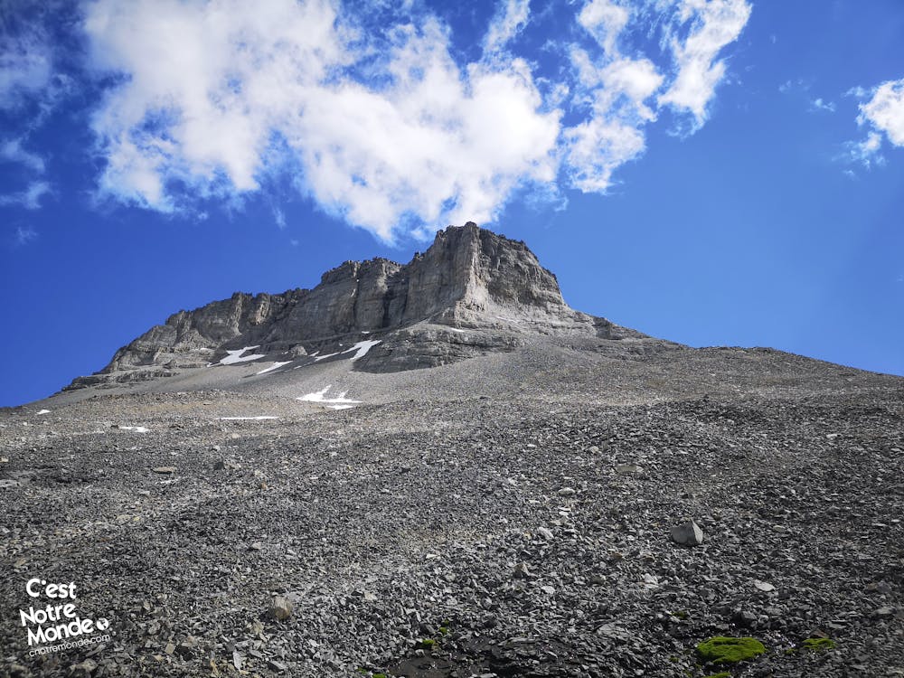
Continue onwards across a broad scree field to reach Sparrowhawk hut, nestled beneath the summit on the mountain ridge. A well-defined trail through this rocky terrain facilitates the challenging 1.2km (0.75mi) traverse with a 430m (1406ft) elevation gain. Upon reaching the shelter, you'll have surpassed the 3000m mark, with only the final push to Mount Sparrowhawk's summit remaining. In adverse weather, the hut provides a safe haven with basic survival gear.
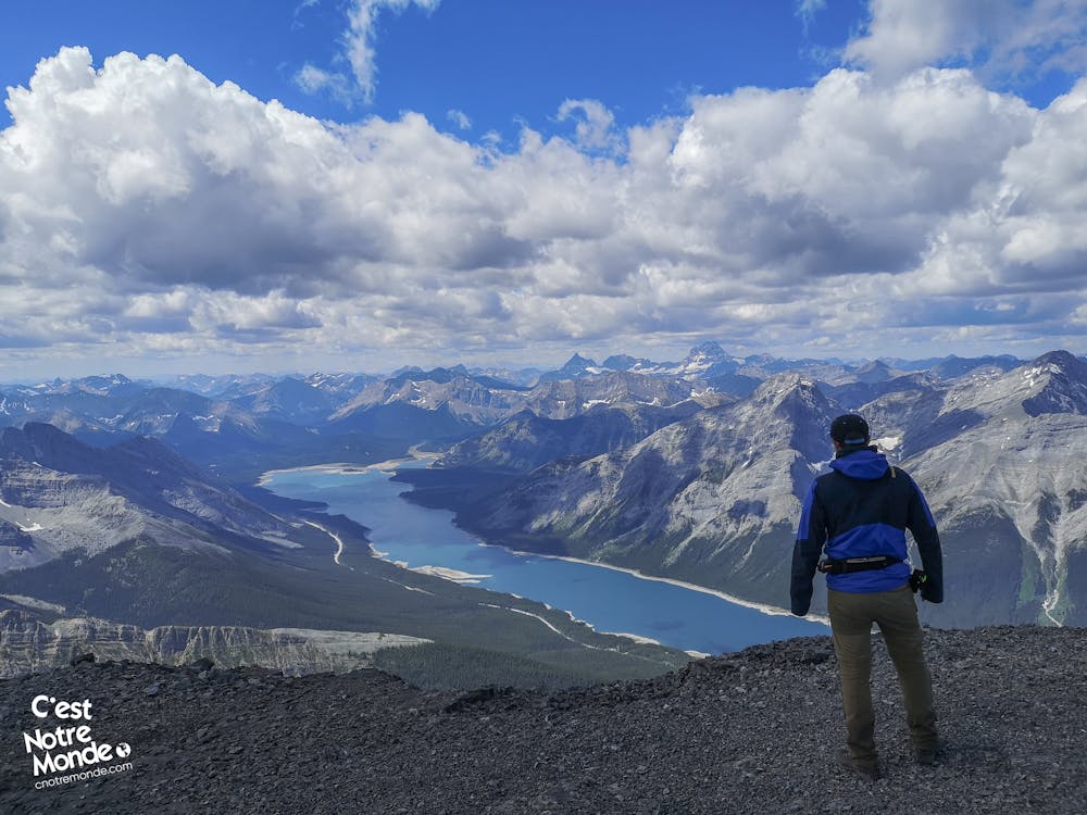
The last leg of the ascent, likely the most demanding (easy scrambling), involves navigating another steep scree slope prone to rockfall. Consider wearing a helmet if other hikers are present. Take your time to savor the awe-inspiring panoramic views from the summit ridge adorned with a prominent cairn. The vista encompasses the highest peaks of Kananaskis Country and Spray Lake, creating an unforgettable experience. Exercise caution as strong winds can prevail at the summit!
For the descent back to the parking lot, retrace your steps along the same trail. Exercise caution, particularly on the section leading to the hut, as the descent can be steep.
FRANÇAIS https://www.cnotremonde.com/randonnees/alberta/mont-sparrowhawk/ Découvre notre première ascension de plus de 3000m dans les Rocheuses Canadiennes : le mont Sparrowhawk ! Cette montagne occupe une place spéciale dans nos aventures. L'ascension jusqu'à son sommet à 3121m (10,240ft) est un défi long mais accessible, ne nécessitant pas de compétences techniques avancées. À travers la forêt et les pierriers, les vues sont à couper le souffle, offrant un panorama saisissant sur le Spray Lake Reservoir et les sommets imposants du Kananaskis Country. Une expérience de scrambling facile à ajouter à ta liste de randonnées inoubliables !
ITINÉRAIRE Depuis le stationnement du "Sparrowhawk Day Use Area", accède facilement au sentier "Read’s Tower Route", clairement identifiable de l’autre côté de la route 742. Après avoir marché 400m (0.25mi), prends à gauche à la première bifurcation. Les premiers 1.3km (0.8mi) de l’itinéraire traversent une forêt avec des sections plus ou moins abruptes, où certains passages sont moins bien tracés. Pour t'orienter, repère les rubans oranges placés sur les arbres.
À la sortie de la forêt, découvre la magie du réservoir Spray Lake aux eaux bleu turquoise. Poursuis sur le sentier jusqu'à une nouvelle intersection. Il est crucial de tourner à gauche, car le sentier de droite mène au sommet du Read’s Tower (2657m / 2717ft), un sommet voisin. L'intersection est signalée par un petit cairn au sol. Le sentier contourne alors les parois vertigineuses de Read’s Tower pour atteindre un petit cirque. Le scrambling commence alors pour sortir de ce cirque et rejoindre un col face au Mont Sparrowhawk, offrant une vue impressionnante sur le sommet de Read’s Tower.
Continue ta progression à travers un large pierrier pour rejoindre la hutte de Sparrohawk, nichée sous le sommet, sur la crête de la montagne. Un sentier traversant ce champ de roche facilite cette traversée ardue de 1.2km (0.75 mi) avec un dénivelé de 430m (1406ft). Une fois à l'abri, tu auras dépassé les 3000m et il te restera un dernier effort pour atteindre le sommet du Mont Sparrowhawk. En cas de météo défavorable, la cabane offre un refuge sûr avec un équipement minimal de survie.
La dernière section de l’ascension est probablement la plus délicate (scrambling facile). C'est à nouveau un pierrier, cette fois-ci très abrupt, où les chutes de pierres sont fréquentes. Si d'autres randonneurs sont présents, il est recommandé de porter un casque. Prends ton temps pour atteindre le sommet, une large crête ornée d'un grand cairn. La vue à 360 degrés sur les sommets les plus hauts de Kananaskis Country et sur le Spray Lake est véritablement remarquable. C'est un endroit vraiment spécial. Attention, les vents peuvent être forts là-haut!
Pour redescendre vers le stationnement, emprunte le même sentier. Sois prudent sur la section menant à la hutte, car la descente est vertigineuse.
Difficult
Hiking trails where obstacles such as rocks or roots are prevalent. Some obstacles can require care to step over or around. At times, the trail can be worn and eroded. The grade of the trail is generally quite steep, and can often lead to strenuous hiking.

The trail contains some obstacles such as outcroppings and rock which could cause injury.
Away from help but easily accessed.
7.8 km away
A steep scramble to a mythical summit in the Canadian Rockies
Extreme Hiking