9.4 km away
Merlin View Loop
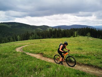
Great loop with some fun and challenging spots.
Moderate Mountain Biking
- Distance
- 13 km
- Ascent
- 420 m
- Descent
- 420 m
Quick Uphill Route to the School
Mountain Biking Moderate

This is a popular mountain biking route which is generally considered to be moderate. It's remote, it features medium exposure and is typically done between February and October. From a low point of 1.3 km to the maximum altitude of 1.3 km, the route covers 1.7 km, 50 vertical metres of ascent and 13 vertical metres of descent.
Fun 1.5KM Uphill, Start Behind the Community Center.
Moderate
Mostly stable trail tread with some variability, with unavoidable obstacles 8in/20cm tall or less. Other obstacles such as rock gullies and steep sections may exist. Ideal for lower intermediate riders.

The trail contains some obstacles such as outcroppings and rock which could cause injury.
Away from help but easily accessed.
9.4 km away
Great loop with some fun and challenging spots.
Moderate Mountain Biking