16 m away
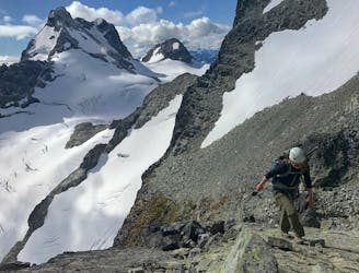
Mt Matier: North Ridge
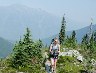
Classic Mountaineer in the Joffree Group
Moderate Alpine Climbing
- Distance
- 17 km
- Ascent
- 1.6 km
- Descent
- 1.6 km
Beautiful scenery, and experience.
Alpine Climbing Moderate

Beautiful scenery and experience. Especially if you start heading up early in the morning, you will get great dawn. The first 4/5km until the hut are pretty easy via the forest and open space, making it accessible even at night. After the hut, you climb on the ridge that leads to Motel 66. The ridge was pretty safe, as far as you don't go too far right as we had some cornices. Between Motel 66 and Anniversary Glacier, you will traverse some inclined terrain. Also, we encounter some wet loose avalanches on our way back, so make sure conditions are good and there are no dangerous hazards above you. We roped up on a flat area before walking on the glacier. A lot of ppl weren't roping up. Up to you, I guess. Better safe than sorry. As you get to the door of the Joffre glacier, you can see Joffre peak on the right and Mt Matier on the left. If you are going for Joffre, you will be turning right as you get to the top of the glacier, and you will start to see the slightly intimidating couloir. As you get closer and start climbing, it gets less intimidating. As you Climb the Couloir, keep right as you will be protected by some rocks and out of the way of people skiing down. We were wearing elements like bits of ice and small debris following down. We used an Ice tool and a ski pole to ascend it. At the top, be careful where you walk. We had a massive cornice that you can't see unless you look at it from the side. So don't get close to the ledge. Instead, start heading left, where you will see Joffre peak for the final 20 meters. The couloir feels a bit sketchy as you're coming down, but it gets easier and easier as you start to descend. Navigating this was pretty easy if you learned the area. Good things FatMap is such an excellent tool for that. Also, bring an SAT phone or an in-reach/spot as there is no signal, not even by the trailhead.


We did this with snowshoes and crampons, but in winter and with snow, this is commonly done with ski touring and split board.
Moderate
May involve slightly more complex glacier hikes, easy but possibly long rock ridges and steep snow up to 45 degrees. Equivalent to PD, PD+

The route features some exposed and/or difficult to protect sections.
Away from help but easily accessed.
16 m away
Classic Mountaineer in the Joffree Group
Moderate Alpine Climbing
133 m away
Scramble Northeast Ridge
Easy Alpine Climbing