Mount Begbie
Revelstoke Mountain Resort
Revelstoke's most visible big peak is an exceptional mountain adventure!
Alpine Climbing Moderate
- Distance
- 16 km
- Ascent
- 2.1 km
- Descent
- 2.1 km
- Low Point
- 664 m
- High Point
- 2.6 km
- Gradient
- 27˚

Towering high above Revelstoke and dominating the view from the ski hill, Mount Begbie is one of this area's major landmarks. The peak isn't hard to climb, but it does require a good level of fitness, glacial travel skills and the ability to do basic and sometimes exposed scrambling moves. If you're fit, able to move safely over glaciated terrain and have solid scrambling skills, you should get on it!

- •
- •
- •
- •
- •
Description
The trip begins with a frankly gruelling hike up about 1400 vertical metres to the Mount Begbie Campground, which is a series of wooden tent pads, an outhouse and a bear cache. No reservation is needed and it's first come, first served. The pads are often full but there is plenty of space to camp within a few hundred metres of the campground, and there's a river flowing to provide water for those camping on or near the tent pads. The most spectacular camping spots of all can be found just above tree line, where the path meets glacial moraine. At the edge of the moraine are some fabulous flat, rocky spots on which to pitch a tent, and all are close to water sources.
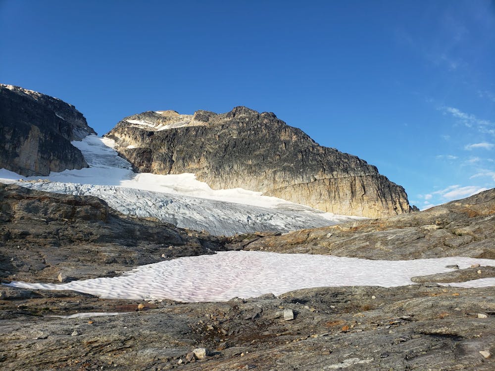
Regardless of where you camp, the first job on summit day is to reach the foot of Mount Begbie's glacier and then don crampons and hike up it to reach the foot of the famous Begbie ledge. In good weather you can't really miss the ledge - just look at Mount Begbie from the edge of the glacier and it's the horizontal line which splits the mountain's east face.
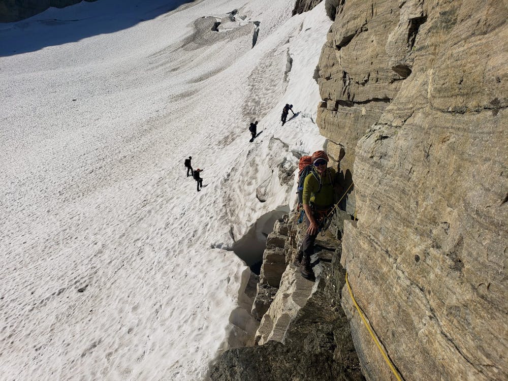
Access to the ledge can be tricky, and might involve a short pitch of rock climbing, or a simple traverse across a snow bridge. Try to get some up to date information on conditions before setting off so you know what to expect! Taking a few cams isn't a bad idea in case you need to do a short rock pitch, and they might come in handy further up the route too. 3 or 4 quickdraws are essential for the route, as are slings to extend them.
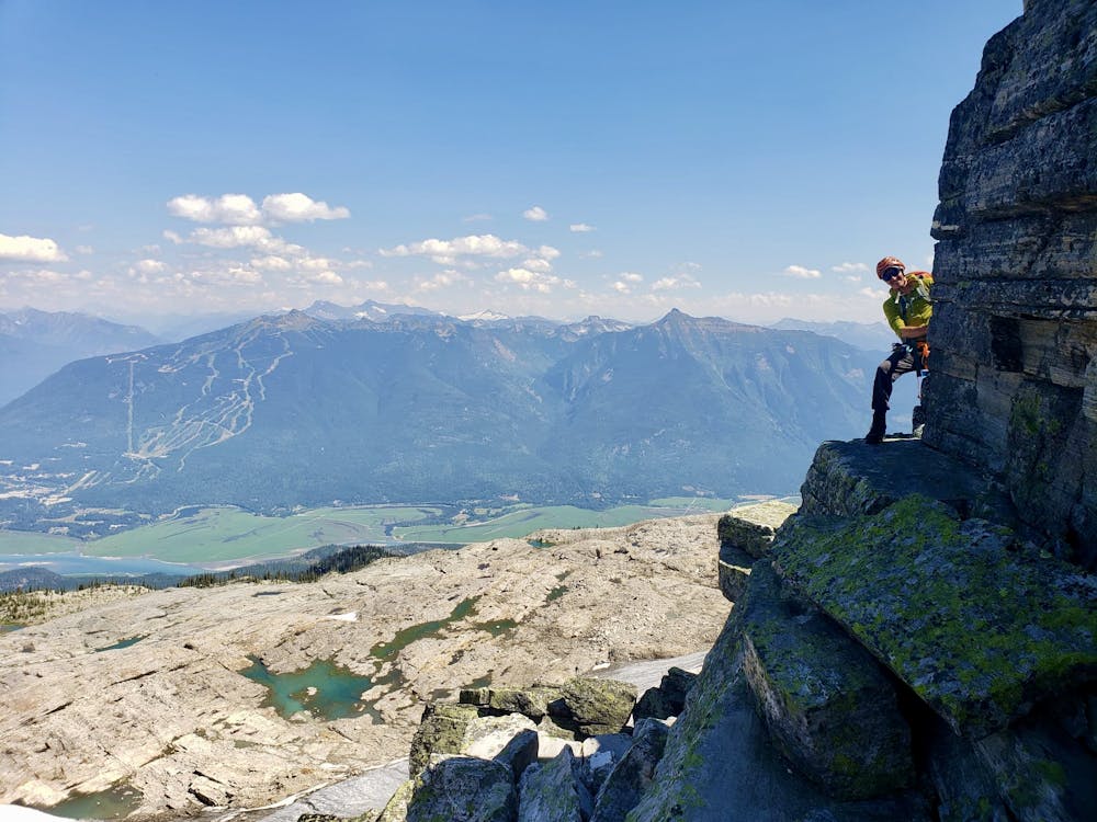
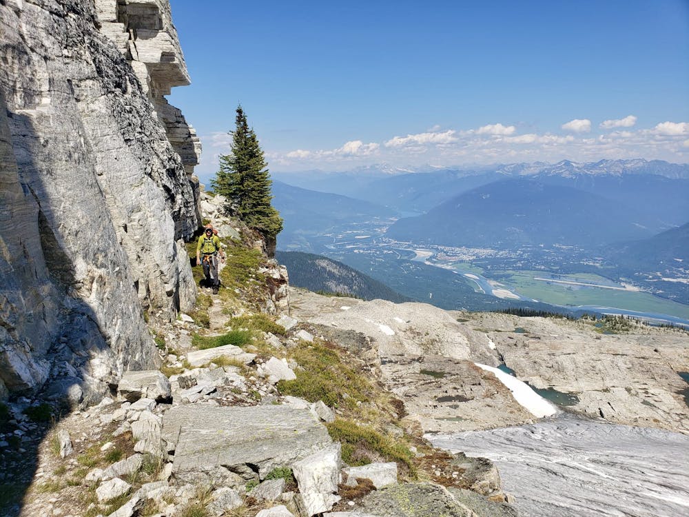
Once on the ledge there are 2 very exposed but simple bits of easy climbing, and these are well protected with bolts. Having done the climbing sections the rest of the ledge is easy (but still exposed) walking and leads to Mount Begbie's north ridge. Climb this, following cairns and signs of wear up simple but sometimes exposed sections of scrambling. Eventually you'll reach a grassy, rounded ridge around 150 vertical metres below Begbie's summit. Stroll triumphantly up this ridge, scramble a few more moves and pull onto the top!
The paucity of the English language makes describing the view impossible, but with the Monashees right next to you and the Selkirks stretching off into the distance when you look the other way, I can assure you that you'll feel the effort to reach the summit was worth making!
To descend, reverse the route! There are several rappel points off the Begbie ledge (which save you reversing the crux pitches) but using them requires you to carry 60 metres of rope, which most parties (wisely) don't consider worth the weight. Reversing the crux pitches and then making a shorter rappel - using a 30 metre rope - back onto the glacier from right at the end of the ledge is the best option.
That hike back down to the parking lot, carrying your camping kit, is pretty heinous but celebratory burgers and beers await you in Revelstoke so just keep on grinding!
Difficulty
Moderate
May involve slightly more complex glacier hikes, easy but possibly long rock ridges and steep snow up to 45 degrees. Equivalent to PD, PD+
High Exposure

Much of the route is difficult to protect and a fall could be disastrous at certain points.
Remoteness
Little chance of being seen or helped in case of an accident.
Best time to visit
Equipment required
- Ice axe
- Crampons
- Quickdraws
- Glacier kit