848 m away
Golden Ears Peak
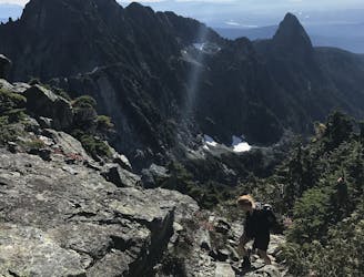
Moderate Scramble to the Iconic Summit.
Extreme Hiking
- Distance
- 22 km
- Ascent
- 1.8 km
- Descent
- 1.8 km
Easy scenic trail that leads to a beautiful waterfall.
Hiking Easy

This is a popular hiking route which is generally considered to be easy. It's remote, it features low exposure and is typically done between April and October. From a low point of 147 m to the maximum altitude of 290 m, the route covers 5.8 km, 185 vertical metres of ascent and 185 vertical metres of descent.
The waterfall.
Easy
Walking along a well-kept trail that’s mostly flat. No obstacles are present.

The path is on completely flat land and potential injury is limited to falling over.

Away from help but easily accessed.
848 m away
Moderate Scramble to the Iconic Summit.
Extreme Hiking