253 m away
Rohr Lake
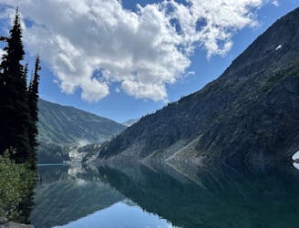
Rohr Lake is a popular—but more difficult—alternative to Joffre Lakes
Extreme Trail Running
- Distance
- 9.6 km
- Ascent
- 559 m
- Descent
- 559 m
Good alpine run on Duffey lake road
Trail Running Moderate

This is a popular trail running route which is generally considered to be moderate. It's very remote, it features medium exposure and is typically done between June and October. From a low point of 1.3 km to the maximum altitude of 2.4 km, the route covers 18 km, 1182 vertical metres of ascent and 1181 vertical metres of descent.
Lovely single track run to an alpine peak. Requires some good navigation, scrambling and some snow travel.
Moderate

The trail contains some obstacles such as outcroppings and rock which could cause injury.

Little chance of being seen or helped in case of an accident.
253 m away
Rohr Lake is a popular—but more difficult—alternative to Joffre Lakes
Extreme Trail Running