4.6 km away
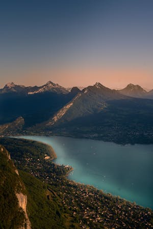
Col de la Forclaz au départ du bout du lac

La vue mythique qu'offre ce col a une autre saveur lorsque que l'on vient d'en bas
Moderate Hiking
- Distance
- 8 km
- Ascent
- 676 m
- Descent
- 677 m
Up and back. Perfect for a half-day tab in the mountains.
Hiking Difficult

This is a popular hiking route which is generally considered to be difficult. It's remote, it features high exposure and is typically done between July and October. From a low point of 1.2 km to the maximum altitude of 2.3 km, the route covers 5.5 km, 1156 vertical metres of ascent and 45 vertical metres of descent.
Up and back Pré Vérel to La Tournette (route goes via Chalet D'Aulp and the Refuge)
Difficult
Hiking trails where obstacles such as rocks or roots are prevalent. Some obstacles can require care to step over or around. At times, the trail can be worn and eroded. The grade of the trail is generally quite steep, and can often lead to strenuous hiking.

Some trail sections have exposed ledges or steep ascents/descents where falling could cause serious injury.

Away from help but easily accessed.
4.6 km away
La vue mythique qu'offre ce col a une autre saveur lorsque que l'on vient d'en bas
Moderate Hiking
15 routes · Hiking · Trail Running