20 m away
Whitesands to Abercastle
Pembrokeshire Coast Path
Difficult Hiking
- Distance
- 23 km
- Ascent
- 722 m
- Descent
- 723 m
Pembrokeshire Coast Path
Hiking Difficult

This is a popular hiking route which is generally considered to be difficult. It's remote, it features medium exposure and is typically done all year round. From a low point of 7 m to the maximum altitude of 166 m, the route covers 7.5 km, 267 vertical metres of ascent and 266 vertical metres of descent.
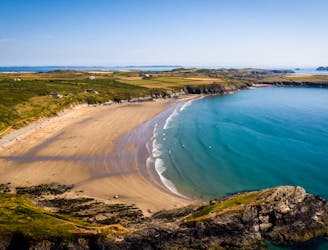
Beautiful walk along the Pembrokeshire Coast Path from Whitesands Beach car park. Heading out to St Davids Head, before making your way up to the top of Carn Llidi to experience 360 amazing views!
Difficult
Hiking trails where obstacles such as rocks or roots are prevalent. Some obstacles can require care to step over or around. At times, the trail can be worn and eroded. The grade of the trail is generally quite steep, and can often lead to strenuous hiking.

The trail contains some obstacles such as outcroppings and rock which could cause injury.
Away from help but easily accessed.
20 m away
Pembrokeshire Coast Path
Difficult Hiking