8 km away
Haunold Couloir
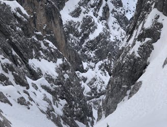
A stunning couloir in Sexten Dolomites.
Difficult Ski Touring
- Distance
- 7.2 km
- Ascent
- 1.3 km
- Descent
- 1.3 km
Ausblick auf Dreizinnen
Ski Touring Moderate

This is a popular ski touring route which is generally considered to be moderate. It's remote, it features medium exposure (e2) and is typically done between November and April. From a low point of 1.5 km to the maximum altitude of 2.5 km, the route covers 6.2 km, 1084 vertical metres of ascent and 3 vertical metres of descent. You'll need skins to complete it safely.
aufstigsrute und die dreizinnen nähe dreizinnenhütte
Moderate
Slopes become slightly steeper at around 25-30 degrees.

As well as the slope itself, there are some obstacles (such as rock outcrops) which could aggravate injury.
Away from help but easily accessed.
8 km away
A stunning couloir in Sexten Dolomites.
Difficult Ski Touring