20 m away
Pizzo Cefalone da Campo Imperatore
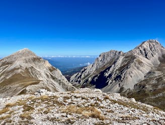
An easily-accessible hike to a beautiful mountain peak.
Extreme Hiking
- Distance
- 8.3 km
- Ascent
- 524 m
- Descent
- 524 m
Salita impegnativa invernale dal Canale sud-ovest del Monte Aquila. Ramponi e piccozza.
Hiking Difficult

This is a popular hiking route which is generally considered to be difficult. It's not remote, it features medium exposure and is typically done between December and March. From a low point of 2.1 km to the maximum altitude of 2.5 km, the route covers 6 km, 550 vertical metres of ascent and 549 vertical metres of descent.
Salita impegnativa (ca.40°) ma molto divertente. Bellissimo il panorama sulla cresta fino al Rifugio Duca d'Aosta. Attenzione ai cornicioni in cresta.
Difficult
Hiking trails where obstacles such as rocks or roots are prevalent. Some obstacles can require care to step over or around. At times, the trail can be worn and eroded. The grade of the trail is generally quite steep, and can often lead to strenuous hiking.

The trail contains some obstacles such as outcroppings and rock which could cause injury.

Close to help in case of emergency.
20 m away
An easily-accessible hike to a beautiful mountain peak.
Extreme Hiking