6 km away
Monte Rosa Haute Route: Margherita Hut and the Grenz Glacier
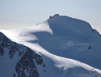
Day 4: Margherita Hut and the Grenz Glacier, beginning at Gnifettti Hut and ending at Neue Monte Rosa Hut
Difficult Ski Touring
- Distance
- 12 km
- Ascent
- 1 km
- Descent
- 1.8 km
Classic ski touring with a long descent on wide slopes.
Also in Aoste, Italy
Ski Touring Difficult

For many years this was a secret route that only the locals knew about, but it has since become a classic and is not to be missed. The descent however, is not very obvious if you don't know the area well and the route itself requires good snow conditions to be a success, so make sure you do your research before you depart.
Head for the middle station at Gabiet, then take the Gabiet chairlift to Lago. At the top, ski down to the lake and traverse across the middle (if the conditions allow it) or stay on the left side of it until you reach the dam guardian's house. There is a small pass which signals the start of the climb on the left side of the hut. Climb up past two narrow valleys that lead to a flat area. The Coppa col will be visible straight ahead. Keep ascending on the right side of the valley, then traverse to the left on a steep slope that leads to the col. Be extremely aware of avalanche risk on this final section. The climb should take approximately two hours.
The first part of the descent is steep and exposed for 100m at around 35°. As the valley then widens, keep to the right side until you reach the first flat area (at 2,300m). The next part of the descent is easy to get wrong - so pay attention: From here follow the valley heading northeast until you reach a little village named Cuttiri (at 2,113m). Keep going left on a narrow path which leads to the village of Pianmisura. Just before the village, follow a gully going down to the last flat area. You will then aim for the Alpe Farinetti via a short ascent and continue to the Alpe Gender. Enter the woods, and follow the path until you reach the last part of the descent from Zube towards Alagna.
Difficult
Serious gradient of 30-38 degrees where a real risk of slipping exists.

As well as the slope itself, there are some obstacles (such as rock outcrops) which could aggravate injury.

In the high mountains or remote conditions, all individuals must be completely autonomous in every situation.
6 km away
Day 4: Margherita Hut and the Grenz Glacier, beginning at Gnifettti Hut and ending at Neue Monte Rosa Hut
Difficult Ski Touring
6.3 km away

One of the most aesthetic couloirs on this side of the mountain
Severe Ski Touring
7.6 km away
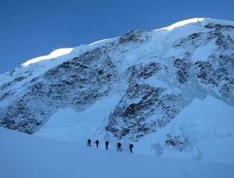
Day 3: Traverse of Passo del Naso of Lyskamm and summit of Pyramid Vincent, beginning at Rifugio Quintino Sella and ending at Capanna Gnifetti.
Severe Ski Touring
7.6 km away
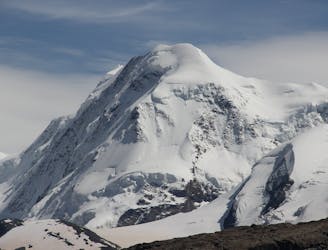
Venture up Switzerland’s famously treacherous Liskamm 4000er, affectionately nicknamed the “people eater”.
Severe Ski Touring

5 routes · Ski Touring

16 routes · Ski Touring