157 m away
Blanhiblar

Great first contact with deep snow
Moderate Freeride Skiing
- Distance
- 350 m
- Ascent
- 0 m
- Descent
- 108 m
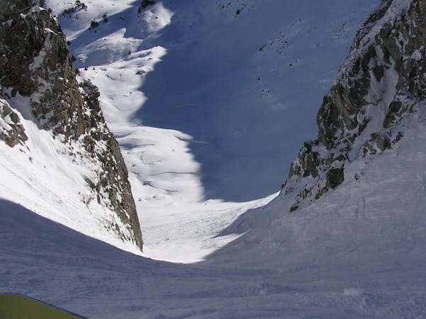
Cliffs and untracked snow.
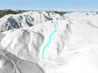
Freeride Skiing Severe

From the top of the Blanhiblar lift, go left and stay parallel to the cafe until you see a small cliff. Follow the base of this cliff along until it disappears and the terrain becomes wider. Try to stay close to the creek, even though it is open terrain; if you go too far left you might end up at some cliffs. This run finishes on the road, 1.5km away from the Beret parking lot. This run has a little bit of everything, skiing along a cliff as well as open areas. Good riders can look for some jumps from the cliffs on the right hand side. The snow conditions in this area are quite tricky, the fact that it is SE facing makes good snow conditions here unusual.
Severe
Steep skiing at 38-45 degrees. This requires very good technique and the risk of falling has serious consequences.

As well as the slope itself, there are some obstacles (such as rock outcrops) which could aggravate injury.

Little chance of being seen or helped in case of an accident.
157 m away
Great first contact with deep snow
Moderate Freeride Skiing
813 m away

Open field
Moderate Freeride Skiing
1.2 km away

Open snow field with easy access, as well as a nice rock jump.
Difficult Freeride Skiing
1.5 km away
Mogul iniation spot
Difficult Freeride Skiing
2 km away

A small trail beside the slope with plenty of jumps.
Moderate Freeride Skiing
2.1 km away

A cruisy creek line
Moderate Freeride Skiing
2.4 km away

A nice tree line opening.
Easy Freeride Skiing
2.4 km away

A tree run under the chairlift
Moderate Freeride Skiing
2.6 km away

A tree run between creeks and boulders.
Moderate Freeride Skiing
2.6 km away

Great fun natural jumps
Moderate Freeride Skiing
10 routes · Freeride Skiing