6.5 km away
Swiss Side Loop
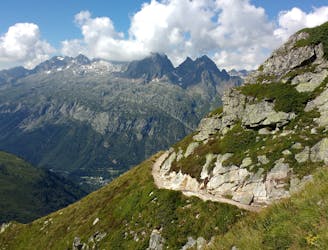
From Le Tour, visit Trient and return along the CCC/UTMB course before discovering the Posettes ridgeline.
Severe Trail Running
- Distance
- 25 km
- Ascent
- 2.2 km
- Descent
- 2.2 km
TMB Trient to Cham via Catogne
Also in Haute-Savoie, France
Trail Running Difficult

This is a popular trail running route which is generally considered to be difficult. It's an unknown remoteness, it features unknown exposure and is typically done in an unknown time of year. From a low point of 1 km to the maximum altitude of 2.2 km, the route covers 26 km, 1832 vertical metres of ascent and 2087 vertical metres of descent.
TMB Trient to Cham via Catogne
Difficult
6.5 km away
From Le Tour, visit Trient and return along the CCC/UTMB course before discovering the Posettes ridgeline.
Severe Trail Running
7.7 km away

Une course dédiée aux jeunes !
Moderate Trail Running

8 routes · Trail Running