5 km away
Chee Dale Circular including the Old East Buxton Lime Kilns
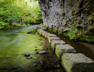
A peaceful stroll through a famous valley which takes in some interesting historical sites
Moderate Hiking
- Distance
- 7.2 km
- Ascent
- 254 m
- Descent
- 254 m
Pomeroy - Dowlow Quarry - Parkhouse Hill - Chrome Hill - Hollins Hill - Hollinsclough - Earl Sterndale - Pomeroy
Hiking Easy

This is a popular hiking route which is generally considered to be easy. It's not remote, it features medium exposure and is typically done all year round. From a low point of 265 m to the maximum altitude of 445 m, the route covers 17 km, 622 vertical metres of ascent and 622 vertical metres of descent.
Pomeroy - Dowlow Quarry - Parkhouse Hill - Chrome Hill - Hollins Hill - Hollinsclough - Earl Sterndale - Pomeroy
Easy
Walking along a well-kept trail that’s mostly flat. No obstacles are present.

The trail contains some obstacles such as outcroppings and rock which could cause injury.

Close to help in case of emergency.
5 km away
A peaceful stroll through a famous valley which takes in some interesting historical sites
Moderate Hiking