2.8 km away
Cadair Idris, Craig Lwyd and Mynydd Moel
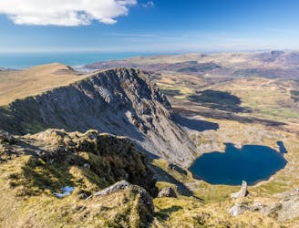
An atmospheric loop over the top of Central Wales' best known summit
Moderate Hiking
- Distance
- 9.6 km
- Ascent
- 920 m
- Descent
- 920 m
Quieter ascent route than common routes but requires better map skills as no obvious path!
Hiking Severe

From Ty'n-y-cornel hotel, clockwise around Tal-y-llyn to Pentre Farm. Follow public footpath NW and enter access land. Continue NNW rising steeply to Craig-Cwm-Anarch. Head NE to rim of Cwm Llyn Cau, follow rim clockwise to Penygadair summit & Trig. Retrace anticlockwise around rim of Cwm Lyn Cau beyond Craig-Cwm-Amarch following Minffordd Path. At east end of Llyn Cau trend clockwise around Craig Lwyd to woodland by Ystrad-gwyn. Leave access land and follow public footpath downhill through woodland to join B4405 by Doleinion. Follow B4405 SW and join permissive track at Fawnog following track, etc anti-clockwise back to Ty'n-y-cornel hotel.
Severe
Hiking challenging trails where simple scrambling, with the occasional use of the hands, is a distinct possibility. The trails are often filled with all manner of obstacles both small and large, and the hills are very steep. Obstacles and challenges are often unexpected and can be unpredictable.

The trail contains some obstacles such as outcroppings and rock which could cause injury.
Away from help but easily accessed.
2.8 km away
An atmospheric loop over the top of Central Wales' best known summit
Moderate Hiking