6.8 km away
Fairy Pools and Coire na Creiche
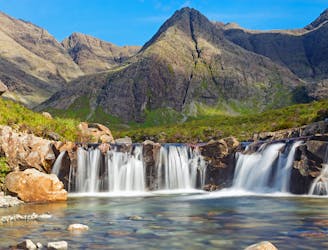
A stunning journey through some of the finest scenery in Scotland
Moderate Hiking
- Distance
- 7.5 km
- Ascent
- 323 m
- Descent
- 324 m
Isle of skye munro well one of the easier ones ,no ropes needed
Hiking Moderate

This is a popular hiking route which is generally considered to be moderate. It's remote, it features medium exposure and is typically done between April and September. From a low point of 48 m to the maximum altitude of 949 m, the route covers 14 km, 902 vertical metres of ascent and 902 vertical metres of descent.
the views are fantastic if your lucky to get a clear daywith great wee ridge
Moderate
Hiking along trails with some uneven terrain and small hills. Small rocks and roots may be present.

The trail contains some obstacles such as outcroppings and rock which could cause injury.
Away from help but easily accessed.
6.8 km away
A stunning journey through some of the finest scenery in Scotland
Moderate Hiking