7.2 km away
Fairy Pools and Coire na Creiche
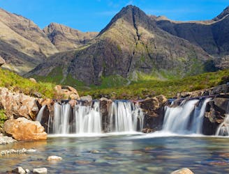
A stunning journey through some of the finest scenery in Scotland
Moderate Hiking
- Distance
- 7.5 km
- Ascent
- 323 m
- Descent
- 324 m
A beautiful walk in with a difficult scramble to reach the summit
Hiking Difficult

This is the tourist route which avoids climbing pinnacle ridge (the ridge to the right on the ascent). This tourist route still requires some difficult scrambling to reach the summit and has some short steeper sections which can be climbed or bypassed to reach the summit.
Going further West along the ridge towards Am Basteir isn't advisable unless you have the equipment needed to abseil down the steepest part.
Difficult
Hiking trails where obstacles such as rocks or roots are prevalent. Some obstacles can require care to step over or around. At times, the trail can be worn and eroded. The grade of the trail is generally quite steep, and can often lead to strenuous hiking.

Some trail sections have exposed ledges or steep ascents/descents where falling could cause serious injury.

Away from help but easily accessed.
7.2 km away
A stunning journey through some of the finest scenery in Scotland
Moderate Hiking