8.1 km away
Lickey Hills Loop
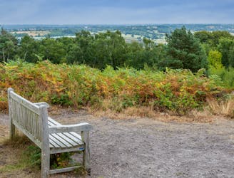
Take in a breathtaking view of Birmingham city centre from some peaceful woods
Moderate Hiking
- Distance
- 7.3 km
- Ascent
- 254 m
- Descent
- 254 m
One of the finest short hikes in the midlands!
Hiking Easy

The Clent Hills cover an area of approximately 1300 acres and rise to a height of around 1,000 feet above sea level. They are characterised by their gentle slopes, open heathland, and woodlands, and are home to a wide range of plant and animal species.

The hills are crisscrossed by a network of walking trails, which range from easy strolls to more challenging hikes. This loop is one of the best day trips in the Clent Hills, and takes you through peaceful woodland, in addition to leading you over Clent Hill itself, home to its 4 famous summit stones.
The origin of the stones is not known with certainty, but they are believed to date back to the Bronze Age, approximately 4,000 to 5,000 years ago.
The stones are made of quartzite and are arranged in a rectangular formation, with three stones standing upright and one lying flat on top. The largest stone is approximately 1.8 meters high, while the others are slightly smaller.
The stones are thought to have been used for ceremonial purposes, possibly as a site for religious or spiritual rituals. They may also have been used as a navigational aid, as they can be seen from a distance and would have provided a useful landmark for travelers.
Over the centuries, the stones have become an important local landmark and a popular destination for hikers and visitors to the Clent Hills. In recent years, they have undergone restoration work to stabilize them and preserve them for future generations to enjoy.
Today, the Clent Hill summit stones continue to hold a special place in the local community, and they are a tangible link to the rich history and heritage of the area.
Suitably humbled by the length of time they've been around, head back to the carpark and the excellent little cafe next to it!
Easy
Walking along a well-kept trail that’s mostly flat. No obstacles are present.

The path is on completely flat land and potential injury is limited to falling over.

Away from help but easily accessed.
8.1 km away
Take in a breathtaking view of Birmingham city centre from some peaceful woods
Moderate Hiking