Salt Trail Canyon to the Little Colorado River
An adventurous and breathtaking trip down to a famous waterway
Hiking Difficult
- Distance
- 12 km
- Ascent
- 1 km
- Descent
- 1 km
- Duration
- 3-4 hrs
- Low Point
- 891 m
- High Point
- 1.7 km
- Gradient
- 25˚

Starting at a designated trailhead, this trip begins with a 2,000 feet descent over a distance of about 6 miles. The trail is known for its steep and rocky terrain, so be prepared for a demanding hike that requires good physical fitness, not to mention sturdy footwear.
Description
As you make your way down, you'll be surrounded by towering sandstone cliffs and colourful rock formations. The canyon walls are adorned with various desert flora, such as cacti and wildflowers, only adding to the beauty of the landscape.
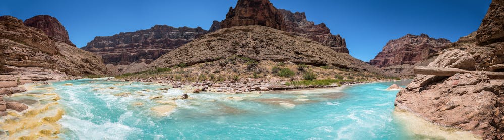
Upon reaching the Little Colorado River, you will be rewarded with a stunning panorama. The river's azure blue water contrasts with the surrounding red cliffs, creating a beautiful vista. The river is known for its clarity, and if weather conditions permit, it's a great spot for swimming!
Before embarking on this hike, remember that the trail can be challenging to navigate, especially during the hotter months, and water sources along the trail are limited. Make sure you carry plenty of water, sunscreen, and snacks, and be mindful of the weather conditions.
Difficulty
Difficult
Hiking trails where obstacles such as rocks or roots are prevalent. Some obstacles can require care to step over or around. At times, the trail can be worn and eroded. The grade of the trail is generally quite steep, and can often lead to strenuous hiking.
Medium Exposure

The trail contains some obstacles such as outcroppings and rock which could cause injury.
Remoteness

Little chance of being seen or helped in case of an accident.
Best time to visit
Features
- Wildlife
- Picturesque
- Water features