8 km away
Deep Creek Hot Springs from Bradford Ridge
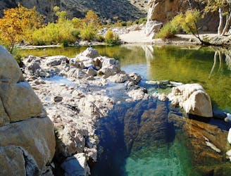
Hot springs and swimming holes in a granite-walled canyon.
Moderate Hiking
- Distance
- 7.5 km
- Ascent
- 418 m
- Descent
- 418 m
Popular swimming hole and cliff jumping spot in a forested canyon.
Hiking Moderate

Alert: Aztec Falls and Splinters Cabin trailhead are closed as of May 2020 due to overcrowding, trash, and graffiti. The Forest Service has not yet announced plans for re-opening as of May 2021.
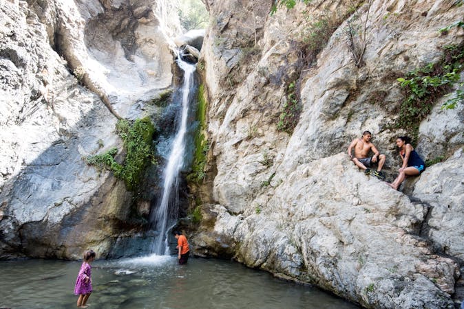
Deep Creek flows from the San Bernardino Mountains, tumbling through a granite canyon lined with tall pines. Within it are countless cascades and pools, but some of the best for swimming are at a spot called Aztec Falls, located along the Pacific Crest Trail (PCT).
Though the PCT traverses many miles of California’s wilderness, the section by Aztec Falls is accessible by a short hike from a dirt road. The road is quite bumpy, but passable to most cars. The hike is short and simple, making it the perfect activity for a hot day, but also making it very popular.
The main swimming hole at Aztec Falls is a deep pool filled by a small waterfall that flows year-round, surrounded by vertical rock walls of varying heights. These rocks make the diving platforms for those who dare. Though it’s dangerous, quite a lot of people come to Aztec Falls to cliff jump. It gets very crowded on any warm weekend, but you can hike farther up or down the creek to look for more secluded pools. Come on a colder day or early morning on a weekday, and you could have the swimming hole all to yourself.
Because Aztec Falls gets so much traffic, it has suffered from graffiti and littering. Please respect the place by not contributing to this degradation. Respect other users by being courteous, not playing loud music, and not taking up too much space near the water.
Sources: https://www.fs.usda.gov/recarea/sbnf/recarea/?recid=26301 https://weekendsherpa.com/stories/aztec-falls-in-lake-arrowhead/
Moderate
Hiking along trails with some uneven terrain and small hills. Small rocks and roots may be present.

The trail contains some obstacles such as outcroppings and rock which could cause injury.
Away from help but easily accessed.
8 km away
Hot springs and swimming holes in a granite-walled canyon.
Moderate Hiking
9 routes · Hiking