4.8 km away
Teddy's Trail Lollipop
A beautiful, easily-accessible snowshoe trail.
Easy Snow Shoeing
- Distance
- 3.5 km
- Ascent
- 110 m
- Descent
- 110 m
A gorgeous road-turned-snowmobile trail climbing a narrow valley alongside a river.
Snow Shoeing Easy

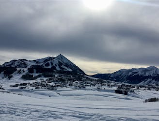
Slate River Road parallels the Slate River as it climbs slowly up the bottom of the valley. While Slate River Road is easily accessible from Crested Butte, it’s impossible to overstate how spectacular the views are from this road! The narrow valley is formed by soaring mountains on both sides, with the ridges to the southwest providing an especially imposing view.


As you work your way up the road, soon a series of snowcapped peaks and beautiful-white ridges will begin to come into view. This is the Paradise Divide area, with notable peaks including Treasury Mountain (13,462ft), Purple Mountain (12,958ft), Augusta Mountain (12,559ft), and more. The further you climb up the valley, the more impressive the views get!
Slate River Road is a multi-use area that is popular with snowmobilers, fat bikers, cross country skiers, snowshoers… and just about any form of over snow travel. This popularity helps keep the road well-packed and navigable by all users, but be sure to exercise common courtesy and trail etiquette as you share the trail with all the other users.
Snowshoers also have the option to hike on nearby trails, including the Lower Loop and Lupine trails. Conditions vary much more dramatically on these trails, and could either be deep powder, a well-compacted track, or anything in between.
Easy

Exposure is limited to that of the slope itself. Getting hurt is still likely if the slope is steep and/or the snow is hard.

Away from help but easily accessed.
4.8 km away
A beautiful, easily-accessible snowshoe trail.
Easy Snow Shoeing