873 m away
Green Mountain via Gregory Canyon
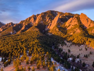
A loop to the top of Boulder's most iconic mountain.
Severe Trail Running
- Distance
- 7.7 km
- Ascent
- 707 m
- Descent
- 707 m
Linking the central flatiron run to green summit and down bear canyon
Trail Running Extreme

Demanding technical 5th class running with a little over 2k' of climbing from the car to the summit of green, including 1,300' of 5th class rock.
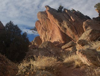
Start from the Chautauqua, and gain the Mesa. Run the Mesa to the old quarry road, and then up the reentrant to the base of the regency. Moderate 5th class terrain takes you to the bench and tunnel of the regency and then to the narrow summit.
Scramble down the back side into the narrow chasm that breaks off the backside and leads to the base of the Royal Arch. A quick 4th class jog deposits you at the overlook, and then moderate 5th class puts you on the summit of the arch. Carefully reverse the 5th class terrain to the bottom and then follow the trail through the arch.
A faint trail to the west of the arch leads to the base of the south ridge on the 5th. A narrow slot forms the start of the route. Scramble up the slot, then climb up to 5.3 on indistinct cracks and face features. Near the summit turn left onto the proper ridge to find the 5.4 crux in a shallow gully. Summit and then downclimb to the large break and traverse left until you find the hole in the flatiron. Drop your pack through and then squirm through the hole. Trend down skiers right to the skinny tree and then find two small holds to lower yourself off onto the broken ledge.
Traverse the west side of the 5th until you come to a faint trail heading south west. Follow that up to the base of the Fist, also called the hippo head. 4th class terrain takes you up on lichen covered rock to a splitter 5.6 hand crack. Climb the crack, turn the summit and then carefully climb down thin slab to the ground. To avoid the hand crack and downclimb traverse climbers left to a huge gash in the rock. Easy scrambling through the gash leads to the summit.
The scramble over the fist links to the broad sandy ridge trending north west and wrapping around to join the ranger trail. Run/hike up loose terrain to a cool skyline ridge. Hold the ridge until it drops you into the saddle and then up onto the ranger trail.
From there, 200' vert takes you to the summit of green. Descend the back side of green to the west until you see bear canyon on the left. Fast flowing running through trees on nice smooth dirt drops you two miles into the canyon.
As you enter the canyon, the trail becomes more technical, with several small water crossings and a ton of techy rock hopping. Soon it opens out back onto the mesa. Turn left and crank down to the water and then run back up onto the NCAR mesa.
Then drop back down skunk canyon and one more hard climb back to the mesa before a cruise downhill to Chautaqua
Extreme

Some trail sections are extremely exposed where falling will almost certainly result in serious injury or death.

Close to help in case of emergency.
873 m away
A loop to the top of Boulder's most iconic mountain.
Severe Trail Running
2.6 km away
A quintessential Boulder trail run.
Severe Trail Running