4.8 km away
Ka'ena Point

An easy hike along an old railroad bed provides stunning views from the westernmost point of Oahu.
Easy Hiking
- Distance
- 8.3 km
- Ascent
- 92 m
- Descent
- 92 m
This long, steep hike on Oahu's north shore leads to a beautiful elevated ridgeline.
Hiking Difficult

If you are looking for a hike that combines stunning views, a good workout, and a variety of terrain, look no further than the Kealia trail on the north shore of Oahu. This 7.3-mile out-and-back trail starts from the Dillingham Airfield and climbs up the Waianae Mountains, offering panoramic vistas of the ocean, the coast, and the valleys.
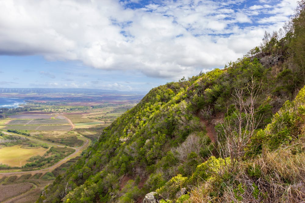
The trail begins on a wide paved road that goes around a chain and forks left. You will soon encounter a series of switchbacks that zigzag up the steep face of the ridge. The trail is well-maintained and marked with signs and mileposts. Along the way, you will enjoy views of the airfield, the Mokuleia coastline, and the Kaena Point. You will also pass through different ecosystems, from dry grasslands to lush forests.
At the top of the switchbacks, you will reach a covered picnic table where you can rest and admire the scenery. The trail continues inland on a dirt road that ascends gradually to the Kuaokala public hunting area. You will pass by an old fence line, a rusted water tank, and a small water catchment. At the junction with the Kuaokala trail, turn right and follow the ridge rim to the end of the trail. You will be overlooking the Makua Valley Military Training Area and the Waianae Range.
The Kealia trail is a rewarding and enjoyable hike that showcases the natural beauty and diversity of Oahu's north shore. It is a great way to escape the crowds and experience some solitude and serenity.
Source: Kealia Trail | Outdoor Project. https://www.outdoorproject.com/united-states/hawaii/kealia-trail Keālia Trail. https://www.gonorthshore.org/ Hiking Kealia Trail: The Western Frontier of Oahu - HomeyHawaii. https://www.homeyhawaii.com/blog/activities/hiking-kealia-trail/ Conversation with Bing Chat
Difficult
Hiking trails where obstacles such as rocks or roots are prevalent. Some obstacles can require care to step over or around. At times, the trail can be worn and eroded. The grade of the trail is generally quite steep, and can often lead to strenuous hiking.

The trail contains some obstacles such as outcroppings and rock which could cause injury.

Little chance of being seen or helped in case of an accident.
4.8 km away
An easy hike along an old railroad bed provides stunning views from the westernmost point of Oahu.
Easy Hiking

16 routes · Hiking