4.4 km away
Honolua Bay
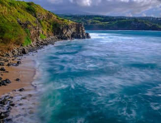
An easy hike down to a gorgeous bay that's popular with surfers and snorkelers.
Easy Hiking
- Distance
- 981 m
- Ascent
- 13 m
- Descent
- 13 m
Hike to an incredible blowhole on the shores of Maui.
Hiking Difficult

The Nakalele Blowhole hiking trail is a short and rugged hike that leads to a natural wonder on the northwestern tip of Maui. This trail is one of the most scenic and diverse trails on the island, offering views of the ocean, cliffs, lava rocks and vegetation.
The trail starts at one of the two parking areas along Highway 30, near mile marker 38 or 39. You will follow a dirt path that descends steeply to the coast. Along the way, you will see signs warning you to stay away from the edge and be careful of slippery rocks. The trail is not well marked, but you can follow the footprints and cairns left by other hikers.
The highlight of the hike is the Nakalele Blowhole, a three-foot diameter hole in a lava shelf above a subterranean ocean cave. As the waves go in and out, water pressure forces ocean spray up to 100 feet out of the blowhole. The blowhole is most active during high tide and strong swells. Do not get too close or try to look inside, as it can be very dangerous.
To complete the hike, you can return along the same trail. Or, you can complete a loop by using a few other trails and a section of the highway.
Sources: Nakalele Blowhole. https://nakaleleblowhole.com/ Nakalele Blowhole — Maui Hikes. https://www.maui-hikes.com/nakalele-blowhole Nakalele Blowhole (100 foot Maui blowhole) - Avenly Lane Travel. https://www.avenlylanetravel.com/nakalele-blowhole-maui/ Conversation with Bing Chat
Difficult
Hiking trails where obstacles such as rocks or roots are prevalent. Some obstacles can require care to step over or around. At times, the trail can be worn and eroded. The grade of the trail is generally quite steep, and can often lead to strenuous hiking.
4.4 km away
An easy hike down to a gorgeous bay that's popular with surfers and snorkelers.
Easy Hiking