Hiking Eagle Rock Trail
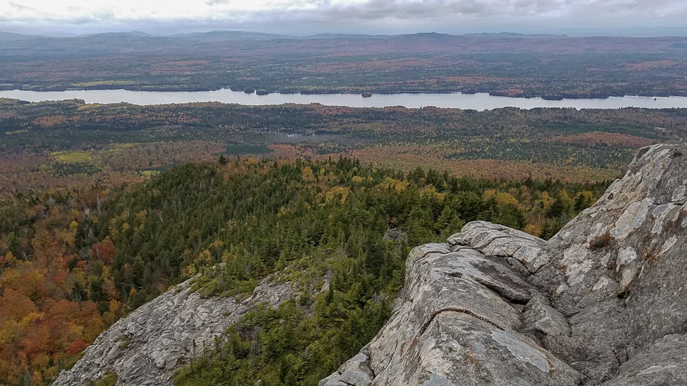
7 mike out-and-back hike through the woods to a rock outcropping with views of Indian Pond and Moosehead Lake
Hiking Difficult
- Distance
- 11 km
- Ascent
- 585 m
- Descent
- 585 m
- Duration
- 3-4 hrs
- Low Point
- 540 m
- High Point
- 773 m
- Gradient
- 10˚

The 7 mile out-and-back hike took me 5 hours to complete, and although the elevation gain is technically only 900 feet, my GPS tracker registered a total ascent of 1,749 feet because of all of the ups and downs on the hike. The views are great from the rock summit as well as the viewpoint at Raven's Ledge, but the rest of the hike is through the woods.
Description
Directions to Trail Head: From the blinking light in the center of Greenville travel north 5.1 miles on Route 6/15. Turn onto the North Road (a dirt road) marked by a sign for Maine Public Reserve Lands – Little Moose Unit. At 8.7 miles turn onto the East Moore Bog Road. At 10.1 miles you will see a gravel parking lot on the right.
For more info about this hike, please visit my blog: <a href="http://www.ericsturgeon.com/blog/hiking-eagle-rock-trail/">Moosehead Eagle Rock Trail Guide - Eric's Maine Life</a>
Difficulty
Difficult
Hiking trails where obstacles such as rocks or roots are prevalent. Some obstacles can require care to step over or around. At times, the trail can be worn and eroded. The grade of the trail is generally quite steep, and can often lead to strenuous hiking.
Medium Exposure

The trail contains some obstacles such as outcroppings and rock which could cause injury.
Remoteness

Little chance of being seen or helped in case of an accident.
Best time to visit
Features
- Picturesque
- Forestry or heavy vegetation