Sky Rim West
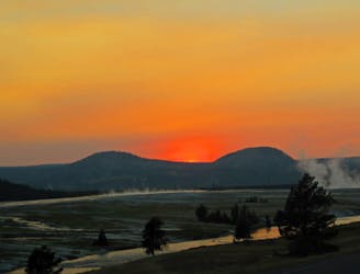
A classic Yellowstone ridgeline loop with tough climbs and epic views.
Severe Hiking
- Distance
- 30 km
- Ascent
- 1.5 km
- Descent
- 1.5 km
A high-elevation traverse on Yellowstone’s remote northern boundary, climbing to mountaintop views not typically seen in this national park.
Hiking Difficult

The Sky Rim is quite unlike most other hikes in Yellowstone. Instead of a meadow or valley trail, it’s an airy traverse of mountaintops and rugged ridgelines. At the border of Yellowstone National Park and Gallatin National Forest, it is far from the national park crowds, and the wild, elevated terrain makes it feel truly a world away.
Because of its remoteness and difficulty, taking on the Sky Rim is a serious endeavor. Water is nonexistent along the ridgeline except in patches of snow that usually melt by mid July. In summer, afternoon thunderstorms are common and lightning is a real danger. High winds, rain, or snow can hit at any time of year. The trek is usually done over two or more days, staying in backcountry campsites at the head of valleys that meet the rim.
The Sky Rim Trail covers 10.7 miles on the spine of the Gallatin Range. It does not have its own trailhead, but is accessed by several others both from the national forest and the national park. The route described here is a 21.7-mile partial loop within Yellowstone National Park, traveling west-east on the Sky Rim via Dailey Creek Trail and finishing on Specimen Creek Trail. This itinerary maximizes mileage and scenery on the Sky Rim, but shorter variations are possible.
Beginning at the Dailey Creek Trailhead along US-191 in Yellowstone National Park, the journey is easy going at first. An obvious dirt path leads through sagebrush and grasses, between the meanders of Dailey Creek on the right and the rocky slopes of Crown Butte on the left. Soon you cross the creek on a footbridge and continue through the broad meadows and sparse trees of this valley. In early summer you may get your feet wet crossing small streams and marshy ground near the creek.
In 1.9 miles comes the junction with Black Butte-Dailey Creek Cutoff Trail on the right. This trail can be used to complete a full loop if hiking only the western portion of the Sky Rim Trail. At 3.6 miles the meadow meets the forest, and the trail enters the shade of dark conifer trees. There is a campsite (WF2) to the right, which you can use with a backcountry permit from the national park. This is the ideal place to stay if you want to hit the rim in the calm of the morning the next day. From here, the trail climbs another 900 feet in a mile and half to gain the Sky Rim.
Mile 5.0 of Dailey Creek Trail is the junction with Sky Rim, a 4-way intersection at the top of Dailey Pass. To the left is the westernmost mile of the Sky Rim Trail and straight ahead is Dailey Pass Trail #57 in Gallatin National Forest. Turn right to follow the Sky Rim east. By now, you’ve already glimpsed some nice vistas over the Dailey Creek drainage, but much has been obscured by trees. The first really great view is close by.
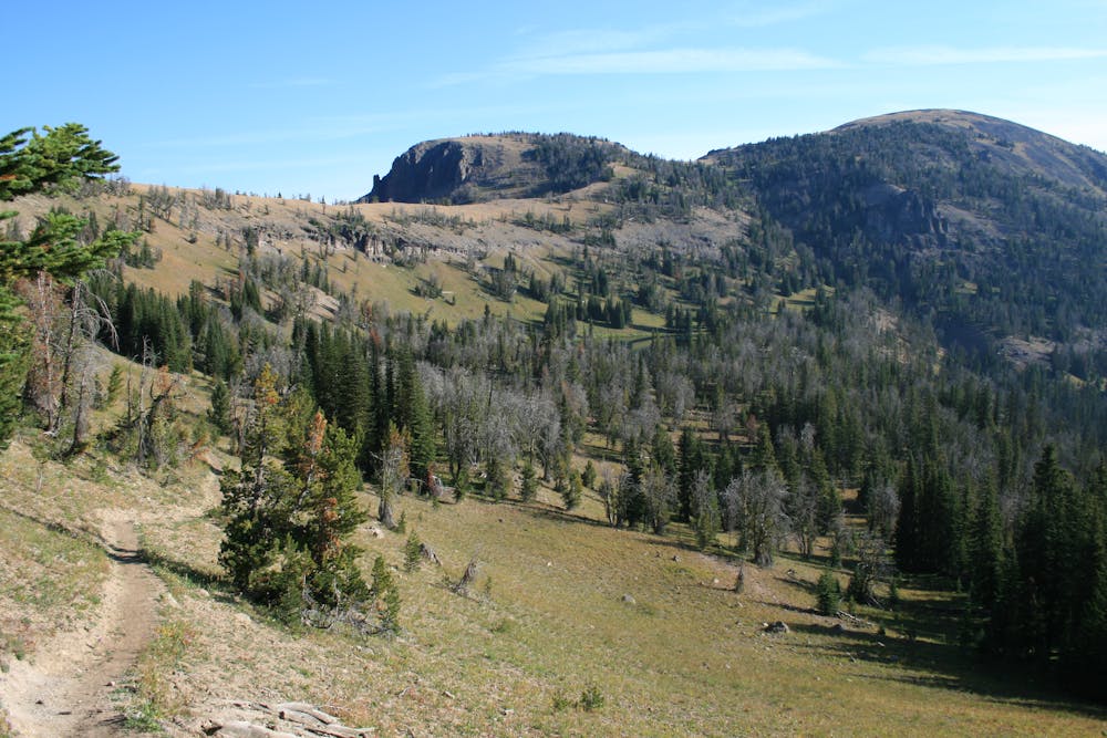
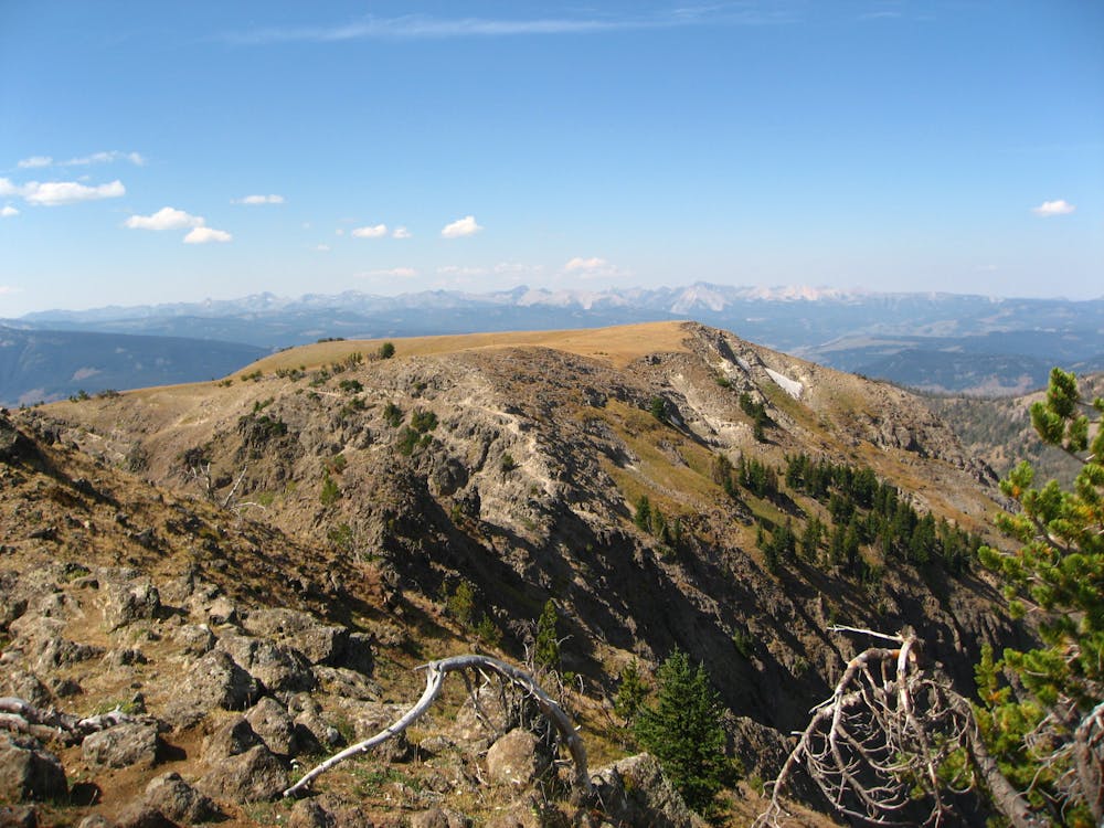
Trees break soon after leaving the trail junction to reveal a bare ridgeline that the trail follows. This is a small taste of the rim, with steep slopes falling away into mountain vistas on either side. It only gets better, though. Climb this hill for 0.7 miles and 600 vertical feet to reach a summit and the junction with Tom Minor Divide Trail. This is you first 360-degree view, though there are still trees to peer through. Turn right to stay on the Sky Rim.
From here the trail climbs gradually as the ridge slopes upward. Gaps in the trees reveal vistas to the south, over the valley you just hiked up. Follow short side trails to the right for better views, and for a chance to see fossilized logs among the talus below, part of the Gallatin Petrified Forest. As you cover more miles and climb higher, trees become sparser and the trail more exposed.
At mile 9.3 the trail enters a summit meadow and ascends more steeply. Tall grass can make it hard to follow, but simply continuing straight across the meadow to the south will reach trail signs and a clearer path once again. The next section of trail stays relatively flat for about half a mile before dropping to the saddle with Bighorn Peak, and the beginning of the Sky Rim’s most daunting obstacle.
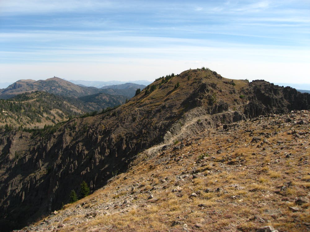
Bighorn Peak is a boulder-strewn bald summit, taller than anything else around--the pinnacle of this ridgeline. At the beginning of a steep climb, another meadow makes the trail hard to follow. Just keep going up. The top of the meadow is the junction with Black Butte Trail, which descends the south slopes of the rim to eventually meet the Cutoff Trail route back to Dailey Creek. Even if you are taking this abbreviated loop, the side trip to the top of Bighorn Peak is well worth the effort.
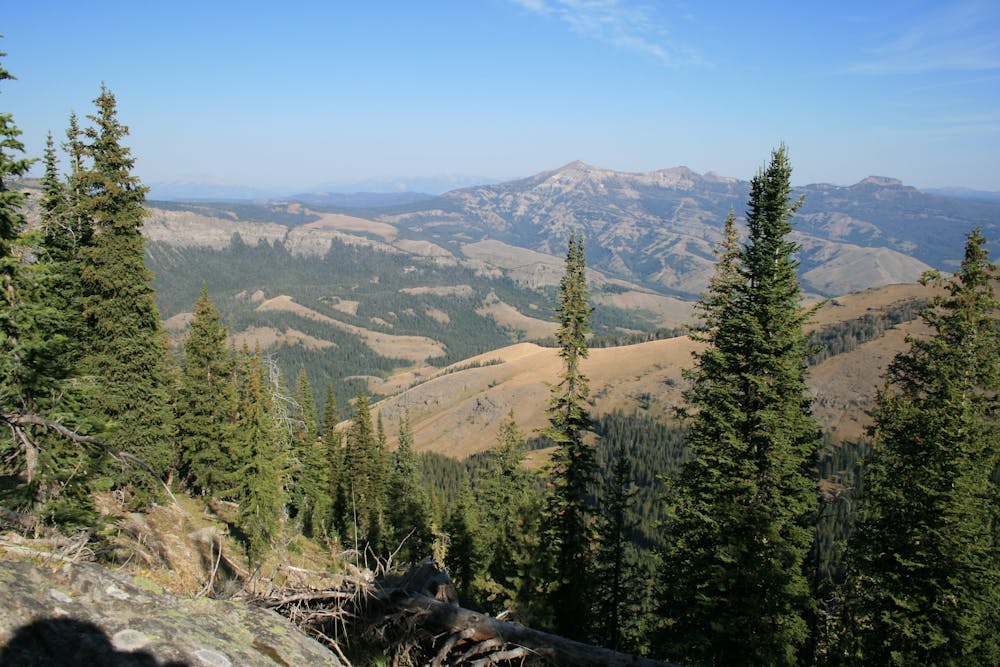
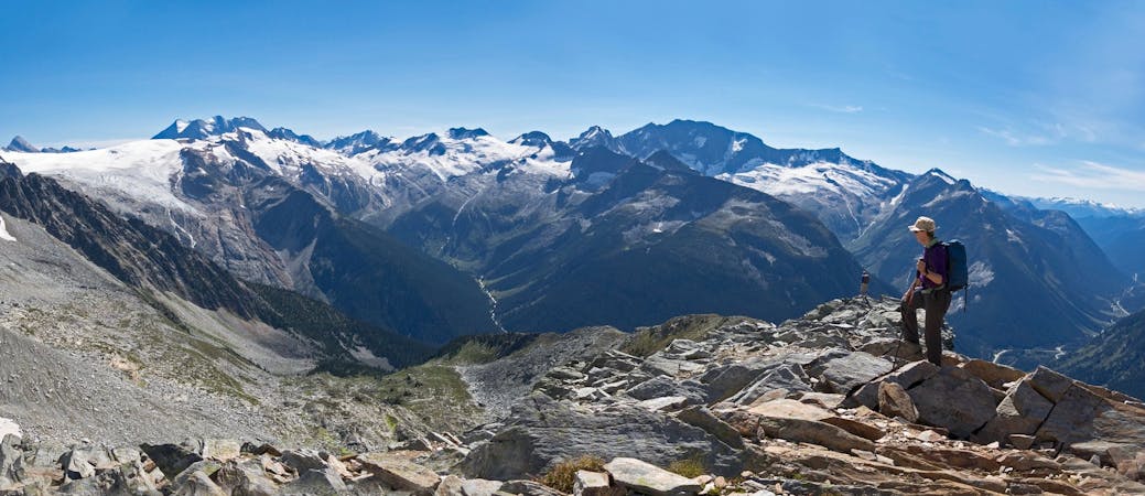
The meadow gives way immediately to a sharp ridgeline guarding Bighorn’s summit. The trail cuts a path pretty much along the crest, weaving among rock pinnacles with sharp dropoffs on either side. It is wide enough and easy to follow, as there’s only one way to go. If you’re afraid of heights just don’t look down. This section is only 0.3 miles, and the summit is the finish. Bighorn Peak affords one of the most astounding views in all of Yellowstone, with vantage over nearly all of the Gallatins. At 9930 feet, it is not the tallest in the range or even on the Sky Rim Trail, but is the high point of this section between Dailey Creek and Specimen Creek Trails. Sheep Mountain, an even higher summit, is visible to the northeast, where the trail now leads.
Take the switchbacks down the other side of the summit then follow another sparsely treed, grassy ridgeline with sweeping vistas for a few more miles. The terrain has rolling ups and downs, but trends generally downward, dropping a net 600 feet toward Shelf Lake.
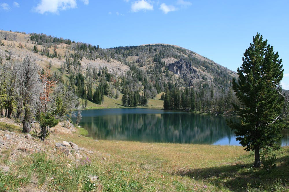
Shelf Lake is perched in an unlikely spot on a narrow bench, just below the ridgeline and just above a cliff band at the head of a valley. Next to the lake are two beautiful backcountry sites (WE7 and WE5), which make a good stopover for backpackers. This is the junction with Specimen Creek Trail and the route down from the Sky Rim, but intrepid hikers may want to take the bonus journey to Sheep Mountain.
One more mile of the Sky Rim Trail lies east of Shelf Lake, and it tops out the trail’s highpoint. Sheep Mountain’s grassy summit is not nearly as rugged as Bighorn Peak, but it is actually taller, at 10095 feet, and offers a panorama equally as expansive. There is a large metal signal repeater constructed on top, however. Return the way you came to take the Specimen Creek Trail down.
The trail descends right away, taking some switchbacks through the forest then following the steep North Fork Specimen Creek. It drops 1400 feet in just over 2 miles before the gradient lessens. The trail is mostly in the forest, but views from intermittent meadows reveal your position in the bottom of a narrow valley hemmed by rocky mountainsides, in between Bighorn Peak to the right and Meldrum Mountain on the left.
At about 5.7 miles down Specimen Creek Trail, or mile 19.1 of the full trip, look closely for more petrified wood in the dirt slopes above the trail to the right. Around this same point, the trail enters an area heavily burned in a 2007 wildfire. After the well-signed junction with Sportsman Lake Trail, it is only 2.1 more miles to the highway at the end of the valley.
Sources: https://www.nps.gov/yell/planyourvisit/maps.htm https://www.backpacker.com/trips/sky-rim-loop https://www.hike734.com/trip/sky-rim-trail-via-dailey-creek/ Day Hiking Yellowstone (book) by Tom Carter
Difficult
Hiking trails where obstacles such as rocks or roots are prevalent. Some obstacles can require care to step over or around. At times, the trail can be worn and eroded. The grade of the trail is generally quite steep, and can often lead to strenuous hiking.

Some trail sections are extremely exposed where falling will almost certainly result in serious injury or death.

Little chance of being seen or helped in case of an accident.
A classic Yellowstone ridgeline loop with tough climbs and epic views.
Severe Hiking
5 routes · Hiking · Trail Running
5 routes · Hiking
5 routes · Hiking · Trail Running