1.7 km away
Elk Flats Trail and Devil's Cauldron Overlook
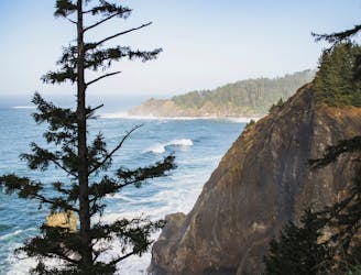
An iconic Oregon Coast hike with stunning views from elevated sea cliffs.
Difficult Hiking
- Distance
- 4.7 km
- Ascent
- 241 m
- Descent
- 240 m
A spectacular trip to a famous part of the Oregon coast
Hiking Moderate

The Cape Falcon Trail takes you through coastal forests, along dramatic cliffs, and to stunning overlooks of the Pacific Ocean. The trail is moderately challenging, with some steep sections and uneven terrain. It's approximately 4.8 miles round trip and takes around 2-3 hours to complete.

Located in Oswald West State Park along the northern Oregon Coast, it offers dense coastal forests of Sitka spruce, western hemlock, and Douglas fir. It is also ined with fern-filled ravines and moss-covered rocks, all of which add to the enchanting atmosphere.
As the trail nears Cape Falcon, it follows the edge of towering cliffs, offering views of the ocean below. The highlight is the Cape Falcon overlook, providing panoramic views of the rugged coastline, crashing waves, towering sea stacks, and pristine beaches.
Moderate
Hiking along trails with some uneven terrain and small hills. Small rocks and roots may be present.

The trail contains some obstacles such as outcroppings and rock which could cause injury.
Away from help but easily accessed.
1.7 km away
An iconic Oregon Coast hike with stunning views from elevated sea cliffs.
Difficult Hiking