Islands in the Sky Loop
A difficult long run route with worthwhile views of Upheaval Dome, Rock formations like Moses and Zeus, and the Marslike slick-rock Terrain of Utah
Trail Running Severe
- Distance
- 32 km
- Ascent
- 752 m
- Descent
- 752 m
- Duration
- 5-6 hrs
- Low Point
- 1.2 km
- High Point
- 1.8 km
- Gradient
- 23˚

This loop and description comes directly from IRunFar.com. This is their description and their directions. I am using them for my run along this route and wanted to share it with FatMaps so others can too.
Description
Here is the link to the article: https://www.irunfar.com/trail-running-in-and-near-moab-utah
Drive to the Upheaval Dome Trailhead in Canyonlands National Park’s Islands in the Sky District, about a 90-minute drive from town. Take the Syncline Trail around the south side of Upheaval Dome, using care to follow the cairns through the areas of slickrock. Along this section, you’ll, at times, have long views that reach as far as the Green River about 20 miles west, with hundreds of layers of sandstone between you and it. At about 3.5 miles in, the Syncline Trail is intersected by the Upheaval Canyon Trail in a dry wash with a sign.
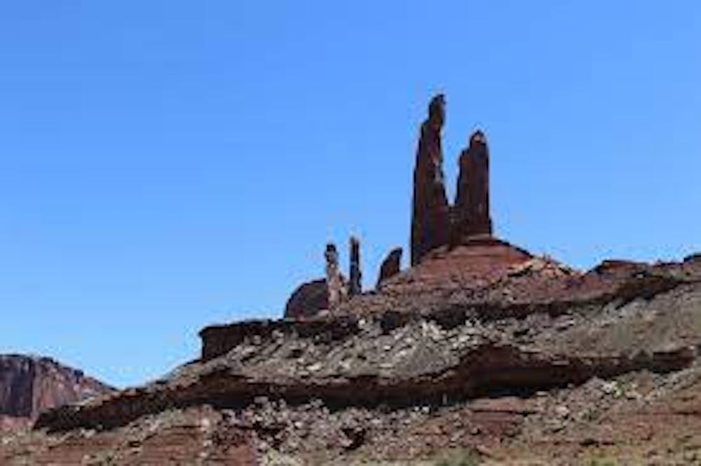
Go left and proceed another 3.5 miles down the Upheaval Canyon Trail which pretty much follows the dry wash all the way to the famous White Rim Road. Go right for a 1/2 mile on the White Rim Road, a 4×4 road used by jeeps and mountain bikes, to the intersection with the rarely driven Taylor Canyon Road. Turn right and begin the five-mile gentle climb up Taylor Canyon Road to the end of the road and the Alcove Springs Trailhead. You’ll have some huge rock spires called Moses and Zeus to inspire your running here.
Run 5.6 miles back to pavement on the Alcove Springs Trail. At first, the trail climbs gently through a sandy dry wash, so use care to follow the cairns. Later, the trail makes a spidery climb past a gorgeous natural and enormous rock alcove. Once you arrive to pavement, turn right and run 1.5-ish miles back to your car at the Upheaval Canyon Trailhead.
Insider’s Scoop: Backcountry navigation skills and a map are critical for success on this loop, as there are many places in which the trail will not seem like a trail. You’re likely to see no one out here – and you won’t have cell service either – so be prepared for 100% self-sufficiency. As is, this loop is just shy of 20 miles. For a fun bonus, take the spur trail to Moses and Zeus. You’ll add on two miles roundtrip, but you’ll also score some great face time with these quirky erosional features.
Risks:
Heat and aridity – May through September see daily highs in the 90s and sometimes 100s Fahrenheit. On every warm-weather excursion, bring with you more water than you think you’ll need.
Cold, aridity, and frozen trails – Wintertime trail running in Moab is sweet stuff, but you’ll find the same aridity of summer as well as cold temperatures. Layer up and carry a lot of water as you’ll be be surprised how dry the air always is. Finally, beware the snow and ice that lingers on trails after recent precipitation events. Last winter, I slipped and fell hard, really hard, on a shaded section of slickrock still covered with ice from a storm a couple days before I arrived. The ice was super-thin and the color of the rock around it, that is to say indetectable, except to my sore tailbone afterward.
Cacti and other things with thorns and spikes – Just avoid them. It’s as simple as that.
Predators – Mountain lions call the Moab region home. Though rarely seen, they are higher on the food chain than you. Consider running with company, especially if you plan to run at night or twilight.
Scorpions, snakes, and spiders – Stuff stings and bites in Moab. Watch where you put your feet and hands. If you take off your shoes for a while, especially if you’re camping and you leave them outside the tent for the night, give them a good shake before putting them back on.
Getting lost – For the sake of yourself, search-and-rescue professionals, and our general trail-running culture, don’t get lost. It’s tempting to run amok when you encounter a place as cool as Moab, but, as they say in places that are not the desert, get yourself in only as deep as you have skills to swim. Always carry a map and, in some cases, a compass. Know how to read/use both. Tell people where you are going and when you’ll be back. And more safety may be found in numbers, so consider running in a group.
Difficulty
Severe
High Exposure

Some trail sections have exposed ledges or steep ascents/descents where falling could cause serious injury.
Remoteness
Little chance of being seen or helped in case of an accident.