8.8 km away
Mount Pilchuck
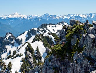
A relatively short hike yields a rewarding mountain summit!
Difficult Hiking
- Distance
- 8.4 km
- Ascent
- 649 m
- Descent
- 648 m
A gentle hike along a mossy canyon, good for family
Hiking Easy

The trail is named for the limestone mining that used to happen here. A kiln to process the limestone into lime was built in the 1890s, and is visible from the trail. The trail is full of leafy undergrowth (and blackberries, when in season!). It ends at a rocky river beach; a good place for a picnic.


Easy
Walking along a well-kept trail that’s mostly flat. No obstacles are present.

The path is on completely flat land and potential injury is limited to falling over.
Close to help in case of emergency.
8.8 km away
A relatively short hike yields a rewarding mountain summit!
Difficult Hiking

10 routes · Hiking