1 m away
Zero G Couloir

A wicked steep and elusive couloir.
Extreme Freeride Skiing
- Distance
- 731 m
- Ascent
- 9 m
- Descent
- 255 m
Access to Pucker Face, Cody Peak runs, The North Shore and more.
Freeride Skiing Severe

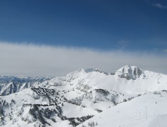
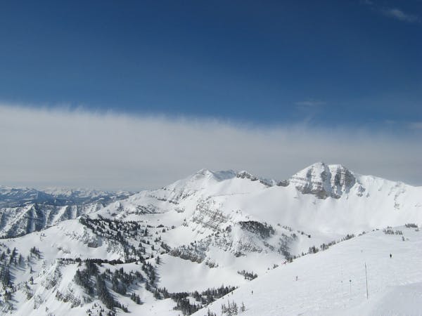
From the top of the Tram, follow the ridgeline south, keeping the ropeline/ boundary markers on your right. At the far end of Rendezvous Bowl you will reach the backcountry gate (you should have past one gate closer to the top of the Tram already, you will know you are at the correct gate if there are small alpine trees on the other side and the rope line has turned eastward down the hill). At the gate, go through your checklist of gear, and mental state to help decide whether you are prepared to exit the ski area boundaries. There is usually posted information on weather and avalanche conditions as well as a beacon check at the gate. Leaving the boundary is no joke, and you will be entering terrain with potentially serious consequences including avalanches, injuries, and death. If ready, continue through the gate following the meandering tracks through the trees heading south then wrapping around to the south-west. You will be following a ridgeline downhill that is hard to define. If there are no tracks, either wait to follow someone who knows where to go or tread slowly ensuring you have not dropped off of the ridge. You should end up through the treed section and on the more defined ridge with Cody Peak directly to the south, and a big bowl leading into the South Fork of Granite Canyon to the North. From the flat spot on this saddled section of the ridge begin bootpacking up the cliff face. This section can be quite technical, requiring steep booting and possibly even scrambling up rock sections. Only ascend high enough to traverse east to the next saddle in the ridge. From this next saddle, continue to boot up the North side of what is now Cardiac Ridge Proper. This side will most likely be wind-scoured rocky. You will remain on this side of the ridge until near the top of Pucker Face. From here, you will be hiking along the ridge line and will be near cornices, cliff faces, and steep terrain. Beware of stepping near any edges as it could result in disaster. Once past Pucker Face, the next open run encountered is east facing No Shadows which begins in the only apparent bowl of the ridge line. Continuing past No Shadows will bring you to the north facing Four Shadows. On the way to Four Shadows you will pass a steep cliff section, known as Triple Cliffs, that is ridable but only if you’re willing to descend multi-stage cliff drops. Past Four Shadows, there is the north facing Central Couloir which slices through the rock buttress of Cody Peak from the top, or Twice is Nice and Once is Enough, which descend the southeast side of Cody Peak. Each of these three runs is very technical, steep, and require true expert skiing ability.
Severe
Steep skiing at 38-45 degrees. This requires very good technique and the risk of falling has serious consequences.

In case of a fall, death is highly likely.
Little chance of being seen or helped in case of an accident.
1 m away
A wicked steep and elusive couloir.
Extreme Freeride Skiing
327 m away
So steep you’ll barely feel the ground underneath you
Severe Freeride Skiing
336 m away

Introduction to Jackson backcountry.
Difficult Freeride Skiing
566 m away
The big show!
Extreme Freeride Skiing
917 m away

A great run, easy hike, fantastic views.
Difficult Freeride Skiing
923 m away

A sneaky chute into Rock Springs Canyon
Difficult Freeride Skiing
1.1 km away

30 minutes to heaven.
Moderate Freeride Skiing
1.3 km away

An enticing face that is more dangerous than it appears.
Severe Freeride Skiing
1.3 km away

Caution Advised!
Extreme Freeride Skiing
1.4 km away

Tight, north-facing trees from the entrance to the Hobacks.
Difficult Freeride Skiing
20 routes · Freeride Skiing