9.2 km away
The MacKenzie River Walk
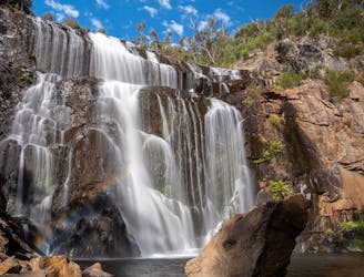
Winding its way along the MacKenzie River, this 8km walk takes in Eucalyptus forest and a number of beautiful waterfalls.
Moderate Hiking
- Distance
- 8.2 km
- Ascent
- 216 m
- Descent
- 216 m
Mount Difficult Circuit Hike
Hiking Severe

This is a popular hiking route which is generally considered to be severe. It's very remote, it features high exposure and is typically done between April and October. From a low point of 329 m to the maximum altitude of 786 m, the route covers 17 km, 931 vertical metres of ascent and 931 vertical metres of descent.
An overnight tour of Mt Difficult.
Severe
Hiking challenging trails where simple scrambling, with the occasional use of the hands, is a distinct possibility. The trails are often filled with all manner of obstacles both small and large, and the hills are very steep. Obstacles and challenges are often unexpected and can be unpredictable.

Some trail sections have exposed ledges or steep ascents/descents where falling could cause serious injury.
Little chance of being seen or helped in case of an accident.
9.2 km away
Winding its way along the MacKenzie River, this 8km walk takes in Eucalyptus forest and a number of beautiful waterfalls.
Moderate Hiking